It’s map Monday. Last week–while working in the collections at the Hennepin History Museum– the Historyapolis team found hundreds of slides from the Minneapolis Housing and Redevelopment Agency (the precursor to our contemporary Community Planning and Economic Development agency ) that illustrated “redevelopment” of Minneapolis engineered by city planners between the 1940s and the 1980s.
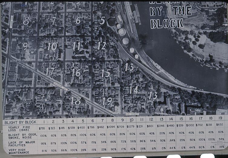
Included in this cache was this map of Cedar Riverside–part of a series that detailed “Blight by the Block” in the city in the second half of the 1940s. The “Blight by the Block” maps were aerial photos annotated with statistics about “blight by odor and noise” and “yearly fire loss” as well as subjective judgments about “lack of major facilities” and levels of maintenance required. While the goal was to use these visuals to make a case for the widespread “redevelopment” of the city’s oldest neighborhoods, this panel demonstrates the somewhat arbitrary nature of measurements for downtown decline.
One of the oldest and most densely populated areas of the city, Cedar-Riverside was the traditional gateway to Minneapolis for immigrant newcomers in the late nineteenth and early twentieth century. Despite the housing crisis of the time, the neighborhood was emptying out in the decades after World War II thanks to restrictions on immigration that had been enacted during the 1920s. Earlier arrivals had been moving deeper into south Minneapolis as soon as they accumulated enough capital to improve their living situation. These immigrant strivers sought larger living quarters, more green space and less dirt. The city’s extensive streetcar system made it relatively easy for factory workers to put more distance between their homes and their sites of employment by the river.
This slide–and the larger “Blight by the Block” educational campaign–reflected the post-war conviction that “downtown is doomed.” Leaders across the country believed that the urban core –with its dropping property values, traffic congestion and deteriorating buildings–threatened the continued vitality of the nation. Planners embraced brash new solutions, turning their back on the more incremental Progressive Era responses to urban congestion and decay. Instead, they championed a bold new ethos of total annihilation. According to historian Alison Isenberg, they believed that “the ‘old’ downtown” had to be destroyed “in order to save it.” Wholesale demolition was the only way–according to planning logic of the time–to address the insidious shortcomings of the urban infrastructure.
One of the lone voices to question this urban planning consensus was Jane Jacobs, a writer and activist based in New York City who believed that the urban redevelopment of the 1950s was not meeting the needs of most people. She argued this point in a 1958 essay for Fortune magazine and a 1961 landmark book, The Death and Life of Great American Cities. This volume–which questioned the planning orthodoxy of the time and is now seen as one of the most important books of urban theory ever written–enraged powerful men like New York City’s Robert Moses, who dismissed Jacobs as a “housewife” and “crazy dame.”
In Minneapolis, Jacobs’ alternative vision for urban life came too late for the Gateway District, the historic heart of the city and the location of the region’s largest skid row, which was leveled between 1958 and 1963. It was also too tardy to save the old commercial district of the near North Side–a center for African American commercial activity–that had been slated for demolition since the 1930s. But she did prove to be an inspiration to activists in Cedar Riverside, who seized on her concepts to mobilize residents to block the flattening of their neighborhood in the 1960s. This activism changed the trajectory for the neighborhood, which now boasts some of the only surviving stretches of nineteenth century streetscapes in the city.