MPLS_1857_MIA

Minneapolis: 1858

Published March 21, 2016
KEVIN EHRMAN-SOLBERG

It’s map Monday. Today, we are going back to the 1850s when Minneapolis was little more than a muddy village. Although the city saw a surge of development during the second half of the decade, it was still a far away from the industrial metropolis it would become. The population in 1858 was a meager 4,238 residents. The roads were dirt tracks. There was no fire department. Sewage flowed into the streets, and most city blocks existed in name only.

This was a transitional period for the “Village of Minneapolis.” Although St. Anthony was still the larger town, Minneapolis was rapidly closing the gap. The main draw of Minneapolis over its sister city across the river was the shared headrace canal constructed in 1856. This waterway enabled any mill along the canal to harness the power of the falls. The economic potential of this canal drew in industrialists from around the country. By 1858, “the town site of Minneapolis and [its] water power,” was making the pages of the Washington D.C. Evening Star. As new mills popped up, new residents moved into the city to work them. By the beginning of the next decade, Minneapolis was an undeniable boom town.

The map above offers a snapshot of Minneapolis as it began its transformation from farming village to industrial powerhouse. Drawn by Orlando Talcott in 1858, his “Building Map of Minneapolis” shows a city on the rise. Considering Talcott ran a local land agency when he was not moonlighting as a cartographer, the presentation of the city as a boom town makes sense. Talcott had a vested interest in making Minneapolis appear like a good investment, and he constructed his map to make that argument. The margins are full of detailed depictions of notable local landmarks like the Nicollet House. The price tag—the Nicollet cost $50,000 to build—is also prominently displayed. The legend proudly proclaims that more new buildings went up in 1857 than in all previous years combined, with the “ratio of new to old buildings” an impressive 5:4.

Yet the neatly ordered streets and economic boasts populating the map only tell part of the story. The rough origins of the city are notably absent. The cartographer depicts the new mills, hotels, and mansions built in the city—not the saloons and tenement houses.

This application attempts to offer a more nuanced take on Minneapolis. By exploring Talcott’s map, we can examine the things he chose to omit as well as depict.


The mapping application was built in collaboration with the Borchert Map Library. The 1858 map used in the application was provided courtesy of the Hennepin History Museum. Other sources include: “History of the City of Minneapolis” by Issac Atwater,  Zalusky’s “Early Theater or the History of Entertainment in Minneapolis” and the Washington D.C. Evening Star.

One of the many sinkholes formed in the aftermath of the "tunnel disaster."

“Minneapolis is Ruined”: The Tunnel Disaster of 1869

Published February 22, 2016
KEVIN EHRMAN-SOLBERG

It’s map Monday. Our last post here at Historyapolis dug into the buried history of the Minneapolis riverfront, and explored the intricate tunnel system that powered the city’s milling district. These subterranean canals were the lifeblood of 19th century industry.

Today, we are going back underground to examine another lost piece of industrial history. This web map tells the story of the Eastman tunnel and its catastrophic collapse in 1869—one of the largest disasters the city has ever seen. The tunnel was the brainchild of William Eastman and John Merriam. In 1865, the two businessmen purchased Nicollet Island. They dreamed of exploiting the power of the nearby falls, and in 1868, began constructing a 2,500 foot tailrace tunnel. This tunnel–dug deep below the Mississippi riverbed–would power the mills Eastman and Merriam intended to build on Nicollet Island.

The venture was a fiasco. In 1869, the tunnel collapsed and the river flooded in, creating a massive underground vortex. Over the next six years, recurring collapses turned the riverfront into a series of sinkholes and whirlpools that swallowed multiple mills. Minneapolis and St. Anthony both faced economic ruin. The immense water power “at the base of their prosperity” was at stake. If left unchecked, the “tunnel disaster” could destroy the falls and permanently cripple urban development along the river corridor. Without a waterfall to build on, Minneapolis would lose its reason to exist.

One of the many sinkholes formed in the aftermath of the "tunnel disaster."

One of the many sinkholes formed in the aftermath of the “tunnel disaster.”

This geo-spatial application attempts to shine new light on the tunnel that nearly wiped out the milling district. Click through the application for a tour of the ill-fated tunnel, and see the impact its collapse had on the city.


Images used in this post are from the Hennepin History Museum. The application was built in collaboration with the Borchert Map Library. The 1861 map used in the application was provided courtesy of Borchert. Other sources include: “River of History: A Historic Resource Study of the Mississippi National River and Recreation Area,” “Engineering the Falls: the Corps of Engineers’ Role at St. Anthony Falls,” The Minneapolis Tribune, and the “Field Surveys under Direction of F.C. Farquhar on 1873 and 1875,” from the City of Minneapolis Municipal Archives.

Tailraces_Cover

The Minneapolis Riverfront: An Underground History

Published February 1, 2016
KEVIN EHRMAN-SOLBERG

It’s map Monday. Today, we have an interactive mapping application built by former Historyapolis intern–and current graduate assistant at the Borchert Map Library–Kevin Ehrman-Solberg.

This web map digs deep into the buried history of the Minneapolis riverfront. While residents readily embrace the “Mill City” moniker, that celebration is usually limited to the surface remnants of the city’s industrial heritage. The flour mills lining the river corridor get the narrative glory. These stately structures are undeniably impressive. Both the Pillsbury A-Mill and the Washburn A-Mill (now Gold Medal Flour), are deservedly two of the most recognizable Minneapolis landmarks. Yet they only tell part of the story.

A complicated system of buried canals, headraces, and tailrace tunnels honeycomb both sides of the river and powered the 19th century milling districts. These networks are the unsung hero of Minneapolis’ days as the flour capital of the world. Hewed into the soft St. Peter sandstone by pick-axe wielding laborers, these tunnels turned St. Anthony Falls into a municipal power plant.

The system relied on three parts. “Headrace” tunnels diverted water from the river above the falls to the various mills. This water then gushed into a series of drop shafts. Massive turbines—the ones installed under the Pillsbury A Mill in 1881 were the largest in the world—were placed in these shafts to harness the power of the falling water. Finally, the spent water flowed back to the river below the falls through a “tailrace” tunnel.

One of the headrace tunnels in St. Anthony.

One of the headrace tunnels underneath St. Anthony Main

This app attempts to illuminate the importance of these underground networks. You can click through the numbered tabs for a guided tour of the Minneapolis underworld, or simply explore the application yourself!


Images are from the Pillsbury A Mill Tunnel Historic and Engineering Condition Study. The application was built in collaboration with the Borchert Map Library. The 1897 map used in the application was provided courtesy of the Hennepin County Historical Society. Digital copies are hosted by Borchert. Other sources include: “River of History: A Historic Resource Study of the Mississippi National River and Recreation Area,” and “Map of the Minneapolis Manufacturing District, 1880.”

Washington Avenue: Then and Now (Part II)

Published November 17, 2014 by Kevin Ehrman-Solberg

The Minneapolis milling district at Washington Avenue and Sixth Street South. Click on the image to start the interactive tour.

This Washington Avenue “now-and-then visualization” was designed and engineered by Historyapolis intern Kevin Ehrman-Solberg.

Last month, the Historyapolis team constructed a “then-and-now” visualization of the southern side of Washington Avenue. The historical images were culled from The Business Heart of Minneapolis, a promotional book from 1882 that we found this summer in the collection of the Hennepin History Museum. We juxtaposed these drawings with modern imagery to give a street level view of Washington Avenue from Eighth Street South, to Fourth Street North. Now, we are presenting the northern side of the street.

As we explained in our earlier post, this book was commissioned by civic boosters to advertise the city’s prosperity. A nineteenth century marketing gimmick, this volume portrayed Washington Avenue (the business “heart” of the growing city) though a hand-drawn panorama that folded out accordion-style. Laid on the floor of the Hennepin History Museum, this delicate drawing stretched ten feet long and presented a carefully constructed image of a clean and orderly metropolis.The goal was to lure new investors to the “Gateway of the Northwest.”

This promotional volume gave no hint of the street’s impending transformation. Twenty years after these images were created, Washington Avenue was known as saloon row. One-third of the city’s drinking establishments were located along this commercial artery, which became the backbone of one of the nation’s largest skid rows.

The nineteenth century architecture of Washington Avenue was one of the casualties of the city’s redevelopment (i.e. demolition) of the Gateway District in the late 1950s. As this visualization shows, few of the historical structures remain. An exception is the building on the corner of Washington and Third Avenue North. Now serving as the offices of Edina Reality, this structure used to house a leather shop as well as Clark and Mackroth’s Agricultural Implements. One block down—on the corner of Second Avenue North—the old Loury and Morrison Block is also still standing, although it is currently vacant and boarded. Besides these two brick stalwarts, however, little remains from the days when Washington Avenue was the “Business Heart of Minneapolis.”

Special thanks to Sarah Peterson for her help in compiling the current street-level imagery. And thank you as well to the generous staff of the Hennepin History Museum, who allowed us to bring this source into the digital realm.


Washington Avenue: Then and Now

Published October 21, 2014 by Kevin Ehrman-Solberg

Washington Avenue between First and Nicollet. Click on the image to start the interactive tour.

This Washington Avenue “now-and-then visualization” was designed and engineered by Historyapolis intern Kevin Ehrman-Solberg, who curated the historic images and took the current-day photos of the street. The text for the post was co-written by Kevin Ehrman-Solberg and Kirsten Delegard. 

Few streets in Minneapolis have a past so checkered as Washington Avenue. An important commercial artery during the boom years of the 1880s, the street today is again at the center of a building boom. This digital exhibit uses visuals to compare one version of its nineteenth century facade to the present streetscape.

This digital juxtaposition—which you can view here— shows the complete transformation of Washington Avenue over the last 130 years. Yet these paired images also obscure as much as they reveal, glossing over the turbulent history of one of the city’s original thoroughfares.

This project began this summer when the Historyapolis team found this amazing volume in the Hennepin County Historical Society.


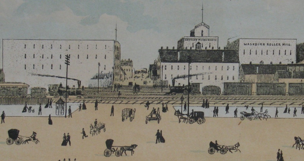
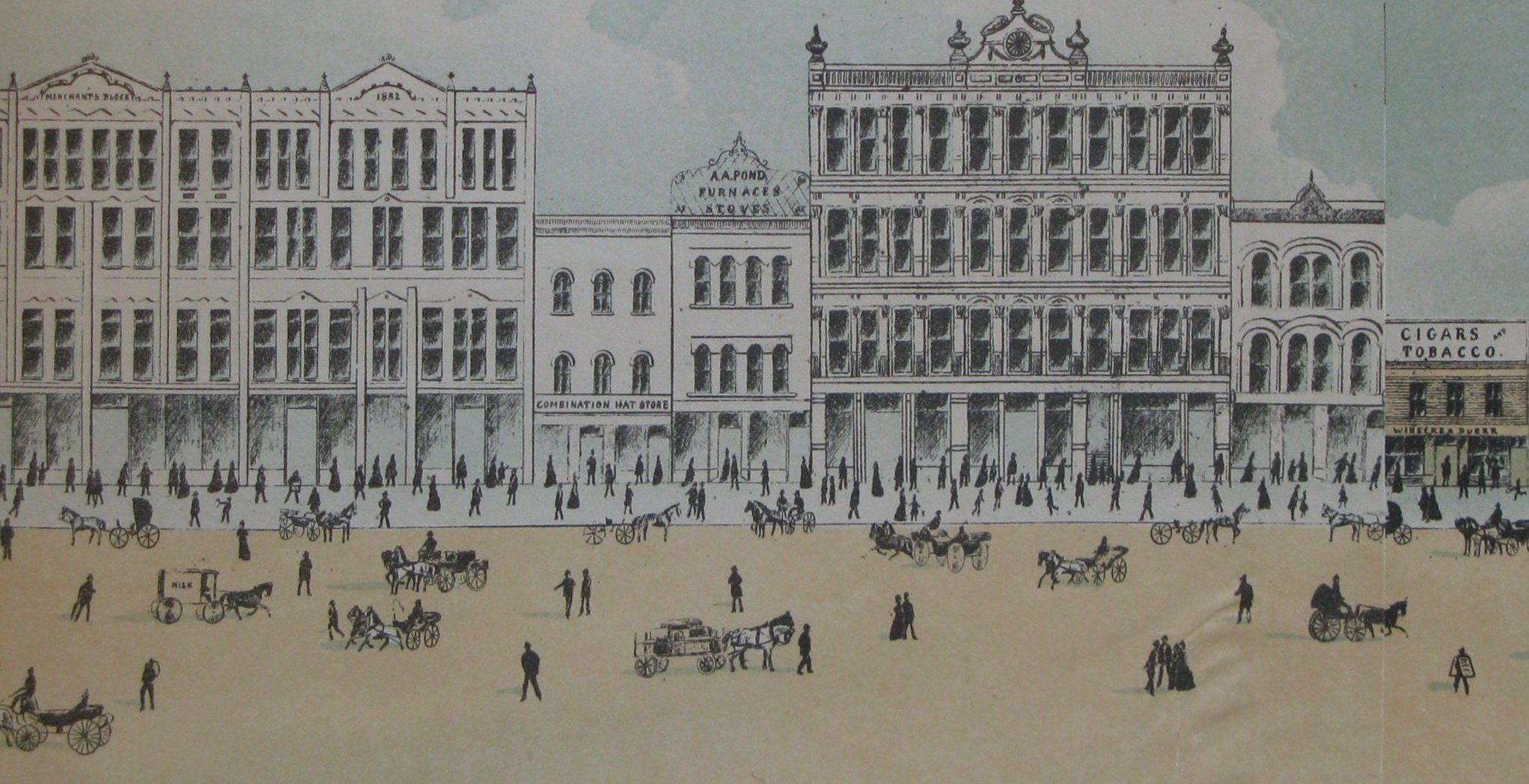
The Business Heart of Minneapolis was a promotional book–commissioned by civic boosters in 1882–that used intricate visuals to advertise the city’s prosperity in an effort to lure new investors. The book folded out accordion-style to reveal a hand-drawn panorama that showed Washington Avenue from Eighth Street South to Fourth Street North. Laid on the floor of the Hennepin History Museum, this delicate drawing stretched ten feet long and presented a carefully constructed image of a clean and orderly metropolis. It had none of the gritty quality of the Hennepin Avenue panorama we found earlier this spring. But like the 1970s montage, the Business Heart of Minneapolis was a Google-style streetview, constructed long before the advent of digital media.

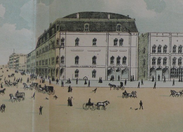
The Academy of Music building on the corner of Washington and Nicollet

The images were fascinating, transporting viewers back to the city during the Nineteenth Century. But they presented a challenge that prompted intense discussions. How could we present them to our readers? How could we use digital tools to share a drawing that stretches ten feet long?

What you see here is the product of these conversations. We decided to use twin image sliders. First, we digitized the original panorama and then cropped it into individual frames. Those images went into the top slider. We then took contemporary photos of Washington and put those underneath. The result is an interactive “now and then” exhibit that lets you compare—block by block—the Washington of the late 19th century with the street today.

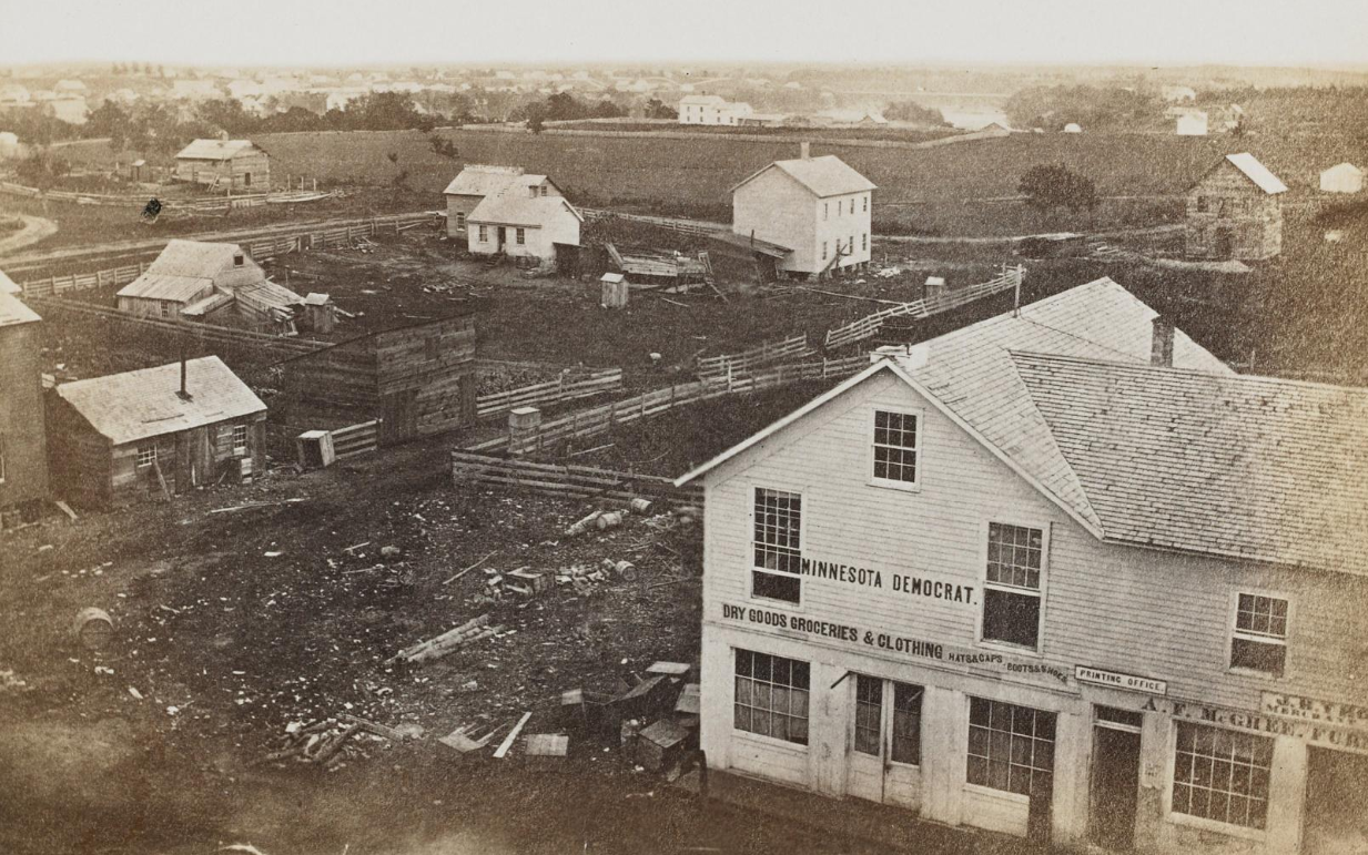
The Business Heart of Minneapolis illustrates the wide variety of business enterprises in operation along Washington Avenue in the last decades of the Nineteenth Century. The panorama featured the Kennedy Brothers gun store, which touted itself as the city’s source for the “best brands of gunpowder.” Shoppers could also peruse its wide selection of “roller and ice skates.” It showed the Anthony Kelly and Co. store, located on the corner of Second Avenue North. The Handbook of Minneapolis published by the Minneapolis Tribune asserted that the wholesale grocer “has in the minds of Northwestern tradesmen and the actual record of commercial life, been associated with all that was honorable in trade.”

A quick look through contemporary photographs and other records shows that the hand-drawn panorama tells only part of the story. It presented a view that was both sanitized and idealized, part of a larger campaign by the business community to convince the world that Minneapolis “has become the wonder of the country,” in the words of the West Hotel Tourists’ Guide. “There is nothing of the mushroom about Minneapolis,” according to the Guide. “Its buildings are the most substantial, its paving of the best material…its business on a sound, conservative basis…its hotels models for larger and older cities.”

The image below, taken by William H. Jacoby, offers a more complex view of this important street.

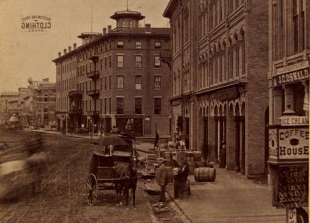
Image courtesy of the Minneapolis Collection at the Hennepin County Libraries Special Collections.

Unpaved streets, wooden plank sidewalks and dirt gutters make a powerful visual argument that Washington Avenue was not a picturesque commercial paradise. Liquor stores like J.C Oswald’s—shown at the far right of the image, next to the Academy of Music building—were far more common than “honorable” tradesmen like Anthony Kelly. The theaters lining the street—many intentionally omitted in the city panorama—were notorious. When the Louvre Theater opened in 1874, the Minneapolis Tribune described the entertainment as  “buffoonery, with all the slang of a bagnio [brothel], and the most indecent gestures conceivable.”

Only a few years after this lavish promotional book was produced, Washington Avenue had been usurped by Nicollet Avenue as the city’s main commercial artery. As retail shifted south, so did the hotels. The Nicollet House on the corner of Nicollet and Washington—which according to Minneapolis Tribune was “for many years the leading hotel of the city”—lost its primacy to the West Hotel on 5th and Hennepin. Washington Avenue, “with its over-supply of rumshops appeals to the vagrant class,” the Minneapolis Tribune declared in 1902. “In front of any of the saloons on this thoroughfare for four of five blocks the loafers congregate and vie with one another in spitting contests. As a rule, they spit toward the curb, but it is usually too far off and the sidewalk is stained a deep brown with tobacco juice, which doesn’t disappear very readily in dry weather.”

In the late nineteenth century, Washington Avenue was a  study in contradictions, with upscale concert halls like the Academy of Music adjacent to bawdy show-houses. By World War I, these contrasts had faded as the street became the center of the region’s largest skid row. A magnet for anyone wanting to buy alcohol or sell sex, Washington Avenue was adjacent to a district of “Female Boarding Houses” (code for brothels), whose inhabitants plied their trade amidst the growing number of dive bars and saloons.

By the 1950s, Washington Avenue had become an unmitigated civic embarrassment. A rat’s nest of liquor stores, beer parlors and flop-houses—where seasonal railroad workers would hunker down through winter at the expense of 50 cents a day—the street bore little resemblance to its glory days as a booming business district. Johnny Rex, the so-called “King of Skid Row,” recounted an episode where a group of girls wrote to him to inquire if they could rent eight of his rooms, because they were attending a basketball tournament in the city. “If you did,” he replied, “you would never be the same. This is Skid Row.”


The corner of Washington and Marquette, taken in the late 1950’s. Johnny Rex’s bar, The Sourdough, is just off frame to the left. Image courtesy of the Hennepin County Historical Society.

It was in this period that the city figured out how to get rid of the Gateway District, which included a large swath of Washington Avenue. Robert Jorvig–who was named the head of the Minneapolis Housing and Redevelopment Authority in 1956–explained that “the Lower Loop” was seen as “a tremendous void on the progress of the City of Minneapolis.” The Gateway “was where all the drunks and alcoholics were,” he asserted. “People got shot down there. You talk about people not going downtown now. In those days, people weren’t worried about crime in the streets and those kinds of things, but if you talked about wandering around on Washington Avenue, people were scared to death.” Jorvig was widely credited with managing the federally-funded effort to redevelop the Gateway between 1958 and 1965, when over 200 buildings, including most of the structures lining Washington, were destroyed.

The street today would be completely unfamiliar to the artist who rendered the drawings of 1882. The building that housed the wholesale grocer of Anthony Kelly and Co. is one of the only survivors of this wholesale demolition. The structure is still there, but is now occupied by Sex World. While jarring, the transition from grocery store to pornography shop does convey the turbulent history of Washington Avenue like nothing else still standing. Condos, coffee shops, corporate offices and parking lots now dominate the rest of the stretch. Of the grand old hotels and seedy dive bars, nothing remains.

Information from: The West Hotel Tourist’s Guide to Minneapolis and its Suburbs, C.W. Johnson, 1886; Tribune Handbook of Minneapolis, The Tribune Company, 1884; “Arts and Culture on the Riverfront,” Hess Rosie and Company, 2006; “Famous Visitors: When Washington Avenue was the Great White-Way,” Beatrice Morosco, 1972; Down on Skidrow, John Bacich and John Lightfoot;  Sanborn maps of Minneapolis, 1912, sections 232 and 245; “Pandemonium,” Minneapolis Tribune, November 11, 1874; “They Loaf and Spit,” Minneapolis Journal, April 25, 1902; “The Ma Who Tore Down the Met,” interview with Robert Jorvig by Sallie Stephenson in 1982, Oral History Collection, Hennepin County Library Special Collections.

Adonis ad for Kevin's pride column

TC Pride: Remembering the Battle of the Bookstores

Published June 27, 2014 by Kevin Ehrman-Solberg

Today’s blogger is Kevin Ehrman-Solberg, Historyapolis intern. 

This weekend, Twin Cities Pride will celebrate the myriad aspects of GLBT life in Minneapolis, which revels in its designation as the “gayest city” in the United States. Pride began as a subdued picnic in Loring Park in 1972 and most people see this quiet gathering as the beginning of a new era of openness for gays and lesbians in the city. It took more than a picnic, however, for queer Minnesotans to win the social, political, and sexual rights they enjoy today.

The struggle for these rights took place in a wide variety of community institutions. But a critical–and often overlooked–battleground for sexual freedom in Minneapolis was the city’s adult bookstores and movie theaters. From 1979 to 1985, the city’s growing adult entertainment industry was the site of intense conflict over the rights of gay men to seek sexual partners in public spaces. A critical turning point for gay rights in the city, this “battle of the bookstores” inspired queer Minneapolitans to seek real political influence in City Hall.

In 1979, police launched a crackdown against the city’s growing pornography industry. They were under intense pressure from neighborhood activists, who objected to the proliferation of pornographic bookstores and movie theaters in South Minneapolis. The ensuing police campaign targeted gay men who used adult bookstores and theaters as sites for sexual encounters. Men in Minneapolis, many of them unwilling to self-identify as gay, had been using those spaces since the early 1970s as a way to engage in sexual contact without fear of physical violence or discovery.

The experience of Mark Weintrob was typical. On August 17, 1982, Mark Weintrob left work and headed to the Adonis Bookstore downtown. He went up to the second floor where a small theater advertised “Hot Male Movies” from “Noon to Midnight.” After taking a seat, he noticed a man staring at him in the dim lights. The two men proceeded to engage in the “normal gay male cruising rituals” until the stranger finally took the initiative and asked Wientrob if he would like to “go somewhere a little more private.” Wientrob followed him to a small boiler room. There, the stranger asked: “Are you a cop?” Wientrob responded with a simple: “No.” “Well I am,” the stranger said, “and you’re under arrest.”

Wientrob became the first man to challenge such an arrest in court. He won, but very few of the men arrested for indecent conduct–a charge used almost exclusively for observed sexual conduct between consenting men–were willing to fight such a charge. Doing so meant public exposure, the very thing these men were trying to avoid.

That exposure could have dire–even fatal–consequences, as the case of the Reverend James Santo illustrates. On December 14, 1982, Santo went into the basement of his Hopkins church and lit himself on fire. His death, and the subsequent investigation, made the front page of the Star and Tribune. “The fire,” the story reads, “which police said may have been caused by Santo pouring gasoline on himself, was preceded 12 hours earlier by his arrest on indecent conduct charges in an adult-oriented bookstore in Minneapolis.” That line is the only mention of the indecent conduct arrest in the Star and Tribune coverage, but it hints at a problem that had been wracking the local gay community for years. Attorney Ken Keate, who regularly represented bookstore arrestees, reported that “about five percent of my calls on these cases are suicide calls.”

The undercover operations of the vice squad netted over 5,000 arrests for indecent conduct between 1979 and 1985. The vast majority of those arrests were gay men. In addition to the shame of such an arrest, many had to endure police brutality when taken into custody.       Activists began to mobilize against this harassment in 1979. But they made little headway until 1985, when a coalition of openly gay politicians and community members were able to force police to scale back their entrapment operations. The political muscle exercised by newly elected gay politicians Brian Coyle, Allan Speer, and Karen Clark, signaled a profound change in the dynamics of the local gay community. The Star Tribune, which had all but ignored the bookstore arrests, suddenly took notice. The paper remarked that the police department’s decision to end vice squad entrapment demonstrated a “broad and well-entrenched political base of support for gays” and was one of the first tangible signs of “growing gay political power.”

“Spend Where You Are Welcome”

Published June 26, 2014 by Kevin Ehrman-Solberg


It’s Pride Week in Minneapolis, and this offers an appropriate opportunity for a visual tour of the city’s historic gay and lesbian press. The images in the above box-slider were digitized by Historyapolis student researcher Kevin Ehrman-Solberg. All images are from 1980’s advertisements that appeared in Equal Time, the GLC Voice, Gaily Planet, and TC Gaze. Tim Campbell, editor of the GLC Voice, regularly encouraged his readers to support the local gay and lesbian businesses. At the beginning of the advertisement section in the Voicethere was often a friendly reminder to “spend where you are welcome.”

Special thanks to Dan Wilhelmsen, the Tretter Collection and the Quatrefoil library.

flowerslogo

“A Practical Guide for the Unpracticed Homosexual”

Published June 23, 2014 by Kevin Ehrman-Solberg

It’s Map Monday. Today we have a series of maps created by Historyapolis student researcher Kevin Ehrman-Solberg.

On August 21, 1970, Hundred Flowers, a radical newspaper from the Cedar-Riverside neighborhood, devoted an entire issue to the burgeoning gay rights movement. “1969 was the year of the New Homosexual,” the paper proclaimed. “New groups, projecting a militant, determined and activist viewpoint arose. The gay person became visible and vocal on a wide scale for the first time. We need your support. Join us in the Freaking Fag Revolution!”

What follows is a mapping of the sites where gays could,according the the paper, “reasonably expect to meet others of the same orientation.” All text, locations, and names are taken directly from Hundred Flowers.

Click on the image below to bring up the map series. You can navigate between the different maps by clicking on the bullet points.

IntroFinal


Summer in the City: Hennepin Avenue, 1970

Published June 4, 2014 by Kirsten Delegard and Kevin Ehrman-Solberg


In the early summer of 1970, an employee of Minneapolis city government did a photographic survey of Hennepin Avenue downtown. The goal was to document six blocks of the city’s most famous avenue, on the border of the newly demolished skid row, where its “bawdy charm” was most pronounced. Developed as a main artery for the nineteenth-century city, Hennepin Avenue was one of the oldest commercial strips in Minneapolis, linking the Mississippi River to the southwestern chain of lakes.

The photographer walked the east and  the west side of the street, taking a series of black and white snapshots in quick succession. The images were developed, printed and then taped into two crude panoramas, each stretching four feet in length. One strip shows the east side of the street; the other shows the west. After Historyapolis citizen-researcher Dan Wilhemsen stumbled on these curled-up panoramas in the tower archives at City Hall, we decided we wanted to share them with all of you.

Click on the slider created by Historyapolis intern Kevin Ehrman-Solberg to see a host of legendary Minneapolis establishments and the surrounding streetscape. This stretch of “the avenue”–as it was called–included the Hotel Andrews; Augie’s Theatre Lounge; the Brass Rail; Rifle Sport; Shinders Bookstore; the Poodle Club; the Saddle Bar; the 620 bar “Where Turkey is King”; Plantation Pancakes; Music City and Musicland; the Hi-Lo 29 Bar; and the Gay ’90s. Catch a glimpse of the Cafe di Napoli, described by Minneapolis booster and columnist Barbara Flanagan as “a Hennepin Avenue landmark and one of the few good restaurants left on that street worth visiting. ”

The photographs are not annotated. But the movie marquees helped us to fix the approximate date they were taken. The Orpheum Theater–a first run cinema at this point –was advertising “Halls of Anger,” which was released on April 29th, 1970. “A Man Called Horse,” which came out on the same day, played at another venue down the block.

Thanks to Google streetview and the increasing fascination with urban “street” art photography, these types of images seems utterly familiar to modern viewers. But there is nothing high-tech or artsy about this project, which was supposed to provide an utilitarian and unvarnished portrait of the city’s grittiest blocks for urban planners and community leaders.

When this panorama was created, this stretch of Hennepin Avenue was viewed as a hard-to-ignore blemish on the face of an otherwise model metropolis. In 1966, the Minneapolis Star called it “a street with a personality problem, beckoning only the more adventuresome to its strip joints, paperback bookstores and streetwalking businesswomen and their agents.” It was encircled by ambitious urban renewal projects, bordering the massive Gateway Center district that sacrificed 40 percent of the downtown in an effort to eradicate the region’s largest skid row. The plan was to replace this nineteenth century streetscape of bars and cage hotels with a futuristic district of skyscrapers. The historic buildings came down. But of course this Minneapolis Futurama never went up.

These images show how the reality of the avenue contrasts with the dazzling vision of city planners. More than a decade after the Gateway redevelopment was supposed to catalyze the creation of a modern city, this panorama reveals how the street was honeycombed with empty lots that generated modest income as surface parking lots. A billboard touting the coming Gateway Center–more than a decade after demolition began–towers over a sea of parked cars.

The increasingly visible role o the commercial sex industry is also obvious. Liberalizing obscenity laws helped to fuel the expansion of adult entertainment establishments in the late 1960s. From this node on Hennepin Avenue they would spread throughout the city, becoming a source of intense community contention that culminated in an ordinance banning pornography in 1983. In these images, shadowy figures loiter outside of anonymous storefronts advertising “Books,” “Magazines ” and “Strictly Adult Entertainment.”

In 1968, the city’s shopping street–Nicollet–had been redeveloped as a pedestrian mall that captured the attention of urban planners around the world. This project was widely imitated and lauded as a new model for American downtowns. The Mall became a mecca for graduate students, foundation researchers and magazine writers who wanted to understand why the city was flourishing while the rest of the country was mired in what was known as the “urban crisis.”

This stretch of Hennepin Avenue was seen as the antithesis of its sister street. “If the Avenues of downtown Minneapolis were personalized, Hennepin would probably be the disheveled and somewhat uninhibited spouse of the well-dressed and proper Nicollet Mall,” a report to the mayor declared. “They are an inseparable pair, going everywhere together, even though the degree of Hennepin’s drinking problem and its deportment and appearance does affect the image of the entire family.”

The success of the Nicollet Mall fanned enthusiasm for large scale urban renewal projects, making the deficiencies of Hennepin Avenue intolerable to city boosters. One year after the completion of Nicollet Mall, they commissioned its designers–Lawrence Halprin & Associates–to create a plan for improvement. But when these plans remained on the drawing board, the Walker Art Center–in cooperation with the Minneapolis Downtown Council and the city Planning Department–organized a symposium that invited artists, architects, designers and urban studies specialists to pitch ideas for revitalizing the avenue. These sessions were held on April 25 -26, 1970 and likely inspired the making of this panorama.

This same event probably also spurred the Minneapolis Tribune writer Allan Holbert to write a piece he called the “Dirty Old Man’s Guide to City,” a tongue-in-cheek description of Hennepin Avenue published during the symposium. Holbert urges readers to visit one of the “friendly bookseller’s shops” on the avenue, since “you’ll probably want to pick out some gifts for the folks back home.” These stores, he explained, offered a selection “ranging from battery-run personal vibrators…to such illustrated magazines as ‘Linda and Laurie,’ ‘Erotic’ and ‘Fun and Games.'” Visitors could also enjoy the show at the Roaring 20s, he explained,  where topless dancers gyrated to some of “the best jazz that can be heard in the Twin Cities.”

As the 1970s unfolded, Minneapolis might have been too busy enjoying its status as an urban paragon to take on the difficult and expensive work of redeveloping Hennepin. City leaders could take solace in the fact that at the depths of the urban crisis, Minneapolis seemed to be defying gravity. While other cities burned, Minneapolis glowed with life.

Moreover, as the Gateway Center redevelopment seemed to lose its momentum and neighborhood activists in Cedar-Riverside organized to halt the wholesale demolition of their neighborhood, critics of urban redevelopment were also gaining visibility. They urged Minneapolitans to embrace “Hennepin’s unpredictability and unconventional behavior” as “interesting and refreshing.” In 1982, it was these very qualities that inspired local artist Patrick Scully to make a quirky film about this stretch of downtown that he called “Shinders to Shinders.” Scully took the same gritty scene and used it as the backdrop for conceptual dance and music pieces that celebrated this stretch of Hennepin as the epicenter of the funky, new-wave urbanity of the 1980s.

It was not until the 1990s that the “avenue” was subjected to a comprehensive redevelopment plan, which changed the streetscape but not the gritty and bawdy character of the city’s entertainment district.

Sources for this post include Allan Holbert, “Dirty Old Man’s Guide to the City,” Minneapolis Tribune, April 26, 1970; The Report to the Mayor: Hennepin Avenue:  Assumptions, Choices, Recommendations, April, 1979, Hennepin History Museum; “How Minneapolis Fends Off the Urban Crisis,” Fortune Magazine, January, 1976; Barbara Flanagan, Minneapolis: City of Lakes and Skyways (Minneapolis: Nodin Press, 1973); “Hennepin: The Future of an Avenue,” Design Quarterly, No. 78/79, 1970: 59-63; Joanna Baymiller, “History of an Avenue,” Design Quarterly, No. 117, Hennepin Avenue (1982): 6-11; Rob Nelson, “Where Were you in ’82?” City Pages, Feburary 6, 2002.

minnehaha tunnel, glass plate negative, city archives

A World Underground

Published May 6, 2014 by Kevin Ehrman-Solberg

Today’s blogger is Kevin Ehrman-Solberg, a senior history major at Augsburg and an intern with the Historyapolis Project.

This haunting image shows a terrain few Minneapolitans ever see. It’s a view of the Minnehaha sewer tunnel in South Minneapolis–part of the vast subterranean complex constructed between the 1880s and the 1930s. This glimpse of the world under the city comes to us through a glass plate negative that we found in the municipal archives, one of many treasures from this forgotten repository in City Hall.

This image was created in the 1920s by the city’s Public Works department to document the largest infrastructure project it had ever undertaken. The Minnehaha sewer tunnel–designed to serve the rapidly growing population of South Minneapolis– ran from Minnehaha Parkway to East 52nd street before veering west and exiting into the river.

This project was greeted with excitement. More than 500 residents –many of them members of the Minnehaha-Nokomis Improvement Association –gathered on an April day to mark the beginning of construction by listening to the Longfellow community orchestra and the Minnehaha school glee club.

This huge tunnel was incredibly expensive to construct, estimated to have cost more than 5 million dollars by chief city sewer engineer Carl Illstrup. The project employed over 200 workers, who used air drills and explosives to hollow out the massive 9 by 13 foot tunnel. The train seen in this photo was used to remove the huge volume of sand, rock, and gravel excavated by workers who dug an average of 12 to 14 feet of tunnel a day.

This work was quite dangerous. Alex Peterson, the “blasting boss” for the Minnehaha tunnel, was seriously injured in a cave-in on August 5th, 1922. That same year, a sewer worker named Fred Gardner died in a different collapse in the Garfield Street tunnel in Northeast Minneapolis.

Today, the Minnehaha tunnel still exists, although it has been converted to a storm drain and no longer deposits raw sewage into the Mississippi.

Material for this post is from “Party Celebrates Start on Sewer,” Minneapolis Morning Tribune, April 23, 1921; “15.5 Miles of New Sewers Constructed by City during 1921,” Minneapolis Morning Tribune, December 27, 1921; “Sewer Tunnel Mile Long Being Dug,” Minneapolis Sunday Tribune, August 28, 1921; “Sewer Scrapbook” located in the Minneapolis City Archives. Glass plate negative from the Minneapolis City Archives.