cropped version, umn18825, hclib, 1885 plat map,  Hopkins, Griffith Morgan

The President Streets

Published February 17, 2014 by Kirsten Delegard

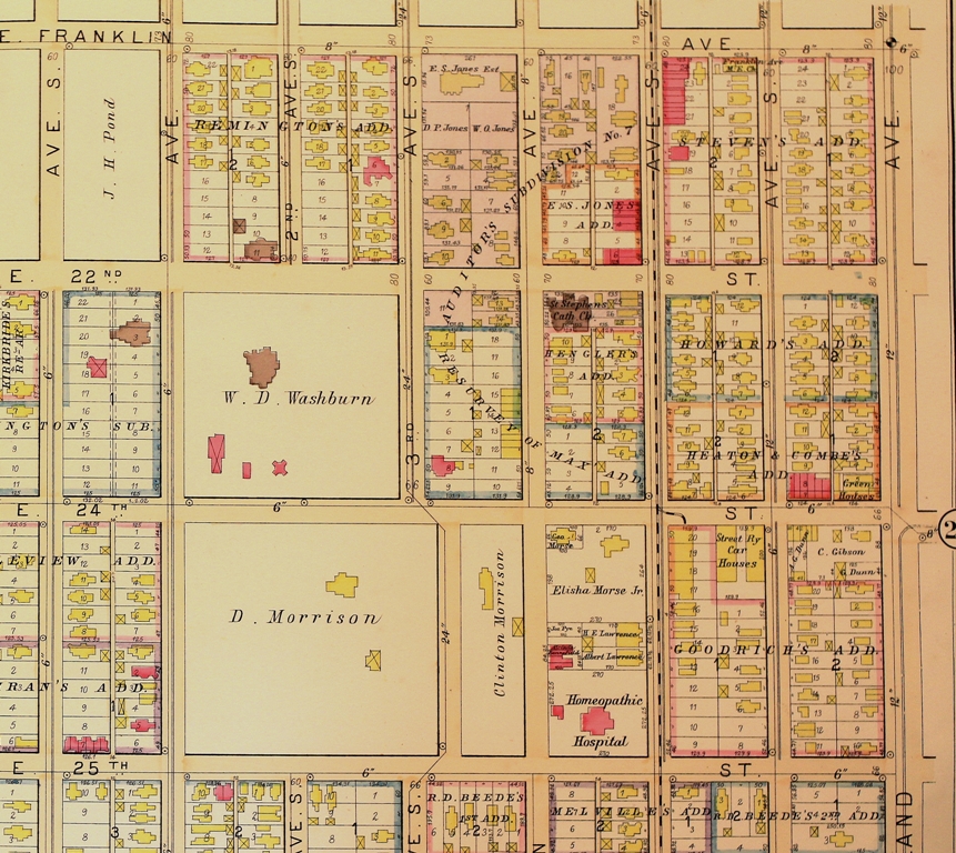
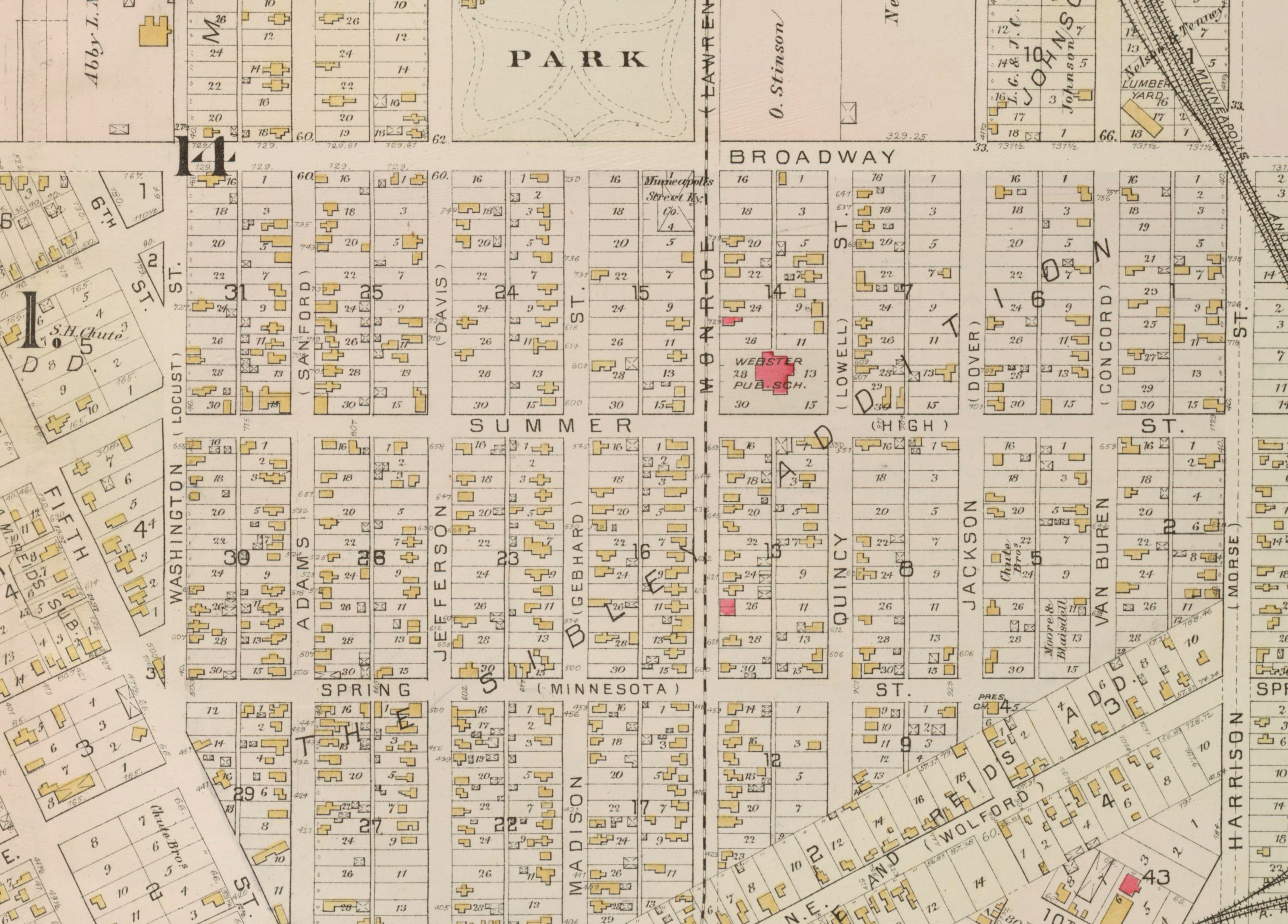
It’s map Monday. And of course, it’s also President’s Day. So here we have a detail from an 1885 map of Northeast Minneapolis that focuses on the President Streets.

Most Minneapolitans know this neighborhood in Nordeast, where you can learn your presidents–and the order in which they were elected–by walking east on Broadway. The street series starts, of course, with Washington. The next street is Adams, followed by Jefferson, Madison, Monroe, Quincy, Jackson, Van Buren, Harrison and so on. This nomenclature was designed to provide an ambulatory history lesson for a neighborhood which has traditionally been home to many immigrants.

I had heard–from several sources–that it was anxieties about these immigrants that prompted city leaders to create the President Streets around World War I. Yet this plat map–created by Griffin Morgan Hopkins in 1885–shows that the President Streets were created much earlier, well before the local Americanization campaign reached its apex.

The Minneapolis Tribune reveals that the President Streets were established in 1872, when Minneapolis and St. Anthony were consolidated into one municipality. “With the union of the two cities the necessity of a change in the system of naming streets and avenues becomes apparent to nearly every one, although all may not agree as to what that change should be,” the newspaper wrote on February 27, 1872. “In old Minneapolis there are several streets of the same name in different parts of the city, and there are few who can tell the location of a majority of the streets. To meet the necessities of the case, and enable old settlers and new ones to tell the location of almost any street mentioned by its name, Franklin Cook, Esq. and others have prepared a plan which will probably find favor on both sides of the river.”

The President Streets were part of a larger plan to rationalize the street grid, according to a scheme that was “thought to embody the best features of that now in New York as well as Philadelphia.” It divided the city into four quadrants. Roads running away from the river were called avenues; those parallel with the river were streets. “Every block shall commence with an even hundred” and house numbering would conform to the streets. In other words, “a person living at 925 Tenth Street will live between Ninth and Tenth Avenue.”

While the new system was adopted it was not without controversy. Yet its defenders were steadfast in the face of those who denounced the reforms as unnecessary, wasteful and confusing. “Minneapolis is one of the handsomest, neatest, most symmetrical cities on the continent and beautifully adapted to the new nomenclature. Shall this city henceforth be a jungle and labyrinth for the stranger to get lost in, or shall it be so systematically laid out as to be a clear path to every man’s foot?” the Tribune editorialized in January, 1873. “Is it possible that there are any among us wishing to abandon so admirable a reform?”

While it was never abandoned, this reform took some time to be universally adopted. This map includes, in parenthesis, next to each President’s name, the street’s original name. Look carefully and you can see that Washington was Locust and Adams was Sanford. More than a decade after the city embraced the great “street nomenclature reform,” this map suggests that some Minneapolitans continued to cling to their original street names. Fifteen years later, however, these names were almost forgotten. This prompted the Tribune to write a feature in 1899 recounting the city’s early geographic nomenclature.

The 1885 Hopkins plat map is Minneapolis collection at the Hennepin County Central Library and digitized on the Minnesota Digital Library. My thanks to James Eli Shiffer, who came up with the idea for this post.

olympic bid cover, second version

“The Olympic winter sports games will be held in Minneapolis in 1928 or 1932”

Published February 14, 2014 by Kirsten Delegard

In 1924, Glenwood Park in Minneapolis hosted the trials for the U.S. Olympic ski team. The success of this event prompted Minneapolis Park Superintendent Theodore Wirth to make a prediction in his report for that year. “The prospects are that the Olympic winter sports games will be held in Minneapolis in 1928 or 1932,” he declared.

Wirth’s optimism proved unfounded. The park that now bears his name would never see a full-fledged Olympic competition, though the city would continue to host Olympic trials for skiing and skating. City leaders failed to parlay community enthusiasm for winter sports into a bid to host the international games, perhaps because the city is rather short on the mountains necessary for alpine competition.

Yet even these geographic realities could not extinguish the Olympic dream in Minneapolis. Twenty years after Wirth saw a winter Olympics in the near future for Minneapolis, a group of business leaders conceived a sophisticated campaign to bring the 1952 summer Olympics to the city. This effort had little to do with athletics. Instead, it was inspired by the widespread desire to resuscitate the reputation of the Mill City.

This scheme was hatched, according to two reporters from Esquire magazine who were covering the Olympic selection process, by “a few newspapermen in  a popular Mill Town eatery back in 1944.” The city demonstrated its commitment to this offer by sending a team to Switzerland to make its case. It then hosted the 1946 NCAA track meet at the University of Minnesota , in the hopes of getting the track and field community in its camp. That same year, the city pulled out all the stops for a visit by Bo Eckelund, the Swedish delegate to the International Olympic Committee.

The city’s most impressive gambit, according to the Esquire journalists, was a slick pamphlet touting the Minneapolis Armory, the University of Minnesota Stadium, the Minneapolis Auditorium, Fort Snelling and Lake Minnetonka as venues for Olympic events. It used spare text and modern graphics to show how the city already had “every major facility necessary to the traditionally fine conduct of this great international event” and could easily “construct or adapt other facilities required.” Printed in English, French and Spanish, the booklet was delivered by air mail to athletic officials throughout the world. “You can wager your gold fillings that such a gimmick cost a mound of dough,” the Esquire writers asserted in April, 1947.

Their description made no mention of the still obscure mayor of Minneapolis, Hubert H. Humphrey, the only politician on the Olympic Invitation Committee of Minneapolis. One year after their dispatch, Humphrey burst onto the national political scene when he delivered a clarion call for civil rights to the 1948 Democratic National Convention. Like former Newark mayor Corey Booker today, the young chief executive of Minneapolis proved expert at garnering headlines. Journalists of the time described him as a “brash, young tornado” and the “most extraordinary politician that Minnesota produced in fifty years.”

As soon as he moved into Minneapolis City Hall, Humphrey began working with the powerful business community to repair the civic reputation of Minneapolis. Since Lincoln Steffens had illuminated the city’s dysfunction in his “Shame of the Cities” series for McClure’s magazine in 1903, Minneapolis had been dogged by dark associations with organized crime, political corruption, labor strife and racial intolerance. Humphrey focused on changing the city’s social climate. He combined vigorous support for racial justice with a fresh intolerance for gangsters and political radicals, whose influence had waxed since the success of the Teamsters’ Strike in 1934. The Olympic Invitation Committee–along with an effort to convince the new United Nations to locate in the Mill City –was undoubtedly part of Humphrey’s larger effort.

These aspiring Olympic hosts believed that the glow of an Olympic torch would banish shadows cast over the city by corruption, intolerance, and employer repression. Ten days of athletic contests and international fellowship would recast the city as a commercial powerhouse and “great vacation area of 10,000 lakes, temperate climate and hospitable people,” in the words of their brochure. The benefits of this transformation were obvious to the business community, which thought that a Minneapolis Olympics would conjure up warm associations for consumers weighing the merits of Cheerios versus Quaker Oats.

The American journalists covering the selection process thought Minneapolis faced its stiffest competition from Detroit, another town with a powerful business community and a highly developed public relations machine. But when the 1948 International Olympic Committee convened in Stockholm, the Mill City lost out to Helsinki, Finland. Olympic organizers were eager to find a location where athletes from east and west could compete, transcending tensions between the United States and the USSR. The escalating Cold War meant that geopolitical concerns outstripped American salesmanship.

Material for this column–including the brochure from the Olympic Invitation Committee of Minneapolis– is from the vertical files at the Minneapolis Collection, Hennepin County Central Library. The quote from Theodore Wirth is from David C. Smith’s Minneapolis Park History.

John Werket Augsburg yearbook

Freeways and Speedskating

Published February 13, 2014 by Kirsten Delegard

When speedskater Johnny Werket returned to Minneapolis after placing sixth in Olympic competition at St. Moritz, his classmates at Augsburg College suspended normal routine to celebrate his accomplishments. The campus welcomed him home with a marching band, assembly and dinner. March, 15, 1948 was declared “Johnny Werket Day.”

Werket would compete in two additional winter Olympics. He would win four championships before turning to coaching. Two of his proteges (Diane Holum and Anne Henning)  won gold medal winners at the 1972 Olympic games in Sapporo, Japan.

Werket was one of four members of the American speedskating team to come from Minneapolis in 1948. Another Minneapolitan– Ken Bartholomew–brought home a silver medal. Two other teammates from the Powderhorn Skating Club– Arthur Seaman and Robert Fitzgerald–also competed for the United States.

These Olympic competitors were all products of the Powderhorn Skating Club, which was based at Powderhorn Park in central Minneapolis. This small urban park–with no real facilities besides a lake–was an international powerhouse for speedskating from the 1930s through the 1950s. Its storied history illuminates how much international athletic competition has changed since the mid-twentieth century.

Powderhorn’s international influence ended, it seems, with the creation of the freeway system in Minneapolis. The construction of a trench for 35W drained Powderhorn Lake, dropping water levels 3.5 feet, their lowest recorded depth. Park historian David C. Smith explains that the Park Board responded to this change by moving the city’s speedskating track to Lake Harriet.

At first glance, the move did not seem to diminish the sport. In 1963, Olympic speedskating trials were again held in Minneapolis. This time two Minneapolitans– Tom Gray and Marie Lawler qualified for the 1964 Olympic team. Lawler was the first woman from Minneapolis to make the Olympic speedskating team.

But the Lake Harriet site was short-lived. The track was again moved to Lake Nokomis, where it seems that competitive speedskating died in Minneapolis. Athletes complained that the lake’s high winds made training difficult. Participation plummeted. The track was closed as part of a large scale cutback of outdoor skating rinks in the early 1980s. A Park Board study showed that outdoor rink use had dropped by half since 1970. This shift had to be driven, in part, by the construction of indoor, climate-controlled skating facilities.

The Park Board tried to bring speedskating back to Powderhorn  in the 1990s. Even with the assistance of skating legend Ken Bartholomew, it could not recapture the glory days of the Powderhorn Skating Club.

Material for his post is taken from the vertical files of the Minneapolis Collection at the Hennepin County Central Library. Source for the connection between Powderhorn Lake and 35W is the park board’s annual report from 1963. The image is page 89 of the 1948 Augsburgian, Augsburg College.


Members of the Powderhorn Skating Club, January, 1947.

“You either skated or did nothing”

Published February 11, 2014 by Kirsten Delegard

Today Minnesota sends Nordic skiers and hockey players to the winter Olympics. Sixty years ago, Minneapolis produced many of the world’s top competitors in speedskating. “Skating was the natural thing for a boy to do then,” explained Ken Bartholomew, who won 14 national championships and an Olympic silver medal for speedskating in 1948. “You either skated or did nothing in those days. You could sled or skate, but after that things were pretty dull in the winter.”

Speedskating got its start among Scandinavian immigrants to the city, who started the Norwegian-American Skating club in 1919. The next year this became the Minneapolis Skating Club, which trained and competed at Lake of the Isles, where the Park Board maintained a quarter mile track during the 1920s.

In 1930, a new track was constructed at one of the most popular parks in Minneapolis. Powderhorn Park quickly became the epicenter of the city’s speedskating culture. The club–with the support of the Minneapolis Park Board and a handful of American Legion posts–trained a generation of athletes who dominated international speedskating competitions for three decades.

Speedskating was inexpensive for athletes, a significant advantage during the Great Depression. And it was exciting to watch. Athletes started in a pack, racing one another instead of the clock. Competitors bumped and knocked each other on the way to the finish line, ending their races bruised and battered. Crashes and take-downs were inevitable on the small track at Powderhorn, where every race required athletes to circumnavigate the oval multiple times.

Powderhorn was renowned across North America for its race course, which hosted national and international speedskating competitions. Athletes called it “the best ice in the United States” and remember it as harder and faster than the artificial surfaces that became common in the 1960s.

For local kids, Powderhorn sponsored the “silver skates” competition, which pitted beginners against one another in a season-long race. At the end of February, the cumulative winner was awarded a pair of skates. It was like the story of Hans Brinker, with a lake instead of canals. Bartholomew won his first Silver Skate race at Powderhorn in 1932.

Powderhorn Park Skate Track, 1934.

Powderhorn Park Skate Track, 1934.

In 1934, 50,000 people flocked to Powderhorn Park to watch the U.S. Outdoor Speedskating Championships, according to park historian David C. Smith. In January 1935, it was the site of tryouts for the 1936 Olympic skating team.  When Olympic tryouts were held at the park again in 1947, four members of the Powderhorn Skating Club made the nine man American team.  Ken Bartholomew won a silver medal in St. Moritz. Johnny Werket placed sixth. Two other Minneapolitans– Arthur Seaman and Robert Fitzgerald–also competed for the United States.

Photos and information for this post is taken from the vertical files of the Minneapolis Collection at the Hennepin County Central Library.

The photo at the top shows members of the Powderhorn Skating Club in January 1947. From left to right we have Gerry Scott (senior woman champion), Ken Bartholomew (Olympic champion) and Bob Dokken, who the newspaper identified as a juvenile champion. The photo in the text shows the Powderhorn race track in 1934, when it was the site of the U.S. Speedskating Championships.


mapofolympicbid

Mapping a Minneapolis Olympics

Published February 10, 2014 by Kirsten Delegard

It’s map Monday. At the end of World War II, a group of Minneapolis businessmen formed the Olympic Invitation Committee of Minneapolis, which put together a bid to host the 1952 summer Olympics. The lovely brochure they printed in English, French and Spanish included this map, showing all the facilities in Minneapolis that could be used for Olympic events. “It shows,” the accompanying text explains, “the relatively small area in which they are concentrated. Officials, athletes and spectators can, therefore, reach any location with ease and speed.”

Note the icon for the “airfield.” This was the Wold-Chamberlain Field barracks, which the Minneapolis organizers touted as a “potential Olympic village,” describing this facility as:

“Sixteen barracks which will house 4,350 athletes

Recreation hall adjacent to barracks

Occupied during the war by United States naval air training unit

Location: Twenty-five minutes from Minneapolis business district”

However primitive, conditions at the former airfield were undoubtedly better than those in Sochi, Russia today, where journalists describe hotels with no heat, running water or doorknobs.

This brochure from the Olympic Invitation Committee of Minneapolis can be located in the vertical files in the Minneapolis Collection at the Hennepin County Central Library.

revsied, cropped map from bill w from augsburg

Castles and Homeopathy, 1892

Published February 3, 2014 by Kirsten Delegard

It’s map Monday. And here we have another plate from the 1892 C.M. Foote & Co real estate atlas. This page shows the blocks now occupied by the Minneapolis Institute of Arts and the Children’s Theater. When this map was made, this corner of the city was dominated by opulent mansions inhabited by some of the city’s wealthiest families.

The grandest of these domiciles was “Fairoaks”- which this map shows as a brown blob in the square marked “W.D. Washburn.” Built at the height of the Gilded Age, Fairoaks was a monument to the excesses of that epoch. This million dollar edifice was more palace than home. Its walls were lined with tapestries and covered with mosaics, stamped leather and woodwork of every variety: ebony, cherry, English oak, rosewood, Circassian walnut and Bird’s-eye maple. Its fireplaces were onyx; its floors marble. Stained glass filtered light in the library; an elevator delivered guests to the billiard room. Eight members of the Washburn family shared 14 bedrooms, at a time when most Minneapolitans crowded into a handful of rooms with loved ones or even strangers. The 10-acre park surrounding the mansion was  designed by Frederick Law Olmsted, who laid out New York City’s Central Park.

Fairoaks was the folly of William D. Washburn, a native of Maine who made a fortune in flour milling and banking. His Soo Line railroad allowed Minneapolis flour to reach eastern markets, helping to make the Mill City into a nationally-known commercial powerhouse. Washburn later parlayed his commercial success into political power, representing Minnesota in both houses of Congress.

Six Washburn children lived into adulthood. None chose to occupy the city’s most lavish abode. Two years before his death, the industrialist donated his estate to the city of Minneapolis, in the hopes it could become a municipal art museum. When the Minneapolis Institute of Arts was constructed across the street in 1915, the city was left wondering what to do with the mansion that demanded constant maintenance. Demolition crews were summoned in 1924; Fair Oaks Park now stands on the site of the Washburn mansion.

None of this information about Washburn or Fair Oaks can be surmised from this map. But this cartographic source provides other insights into the city at the end of the nineteenth century. The Washburn estate stood in close proximity to the Homeopathic Hospital, an institution unfamiliar to me until I saw this grid. A wonderful master’s thesis written by Mary Wittenbreer described the popularity of this branch of medicine in Minneapolis during the 1880s, when the Washburns provided financial support to this institution, which bordered their estate. Homeopathy proved especially popular among women, who became well-versed in mixing tinctures and other homeopathic remedies for a variety of ailments afflicting their families. The homeopathic medical community in Minneapolis played an important role in the development of the city’s first maternity hospital, which was for a time located on this same block.

This plate from the Foote Atlas was scanned for Historyapolis by Bill Wittenbreer, brother of the thesis writer above.

Information about Fairoaks is taken from Larry Millett’s Once There Were Castles. Medical history was provided by Mary Wittenbreer, ” A Woman’s Woman: A Woman’s Physician the Life and Career of Dr. Martha G. Ripley,” (M.A Thesis, Hamline University): 1999.

smaller version, young brothers barber shop

Minneapolis in 1948: ”Where in the heck do black people live around here?”

Published January 28, 2014 by Kirsten Delegard

Matthew Little, civil rights leader, died this past Sunday at the age of 92. A leader of the Minnesota delegation of the 1963 March on Washington, Little was the long-time president of the Minnesota NAACP. He fought to open up hiring practices. He battled segregation in the state’s public schools, filing lawsuits that brought seismic changes to education in Minneapolis. He was a huge force for justice in Minnesota.

A native of Washington, North Carolina, Little had left the South after being denied admission to medical school. In 1948, a flip of a coin sent him to Minneapolis, where he had neither friends nor family.

Little later recounted his earliest days in the city, which was earning a national reputation for racial liberalism thanks to mayor Hubert Humphrey and his municipal Fair Employment Practices Commission. That summer at the Democratic National Convention, Humphrey would put the city on the map when he demanded that the Democratic Party “get out of the shadow of states’ rights and to walk  forthrightly into the bright sunshine of human rights.” But when Little actually arrived in Humphrey’s city, its cold streets were less-than-welcoming to a young black newcomer from the South.

Little “stayed at the YMCA downtown for four days. I walked around the downtown area. I felt so out of place because I didn’t see another black person those whole four days. The other thing was I didn’t realize it was going to be so cold, either.”

Little wandered until he found a police officer and said “”Where in the heck do black people live around here?'” The cop replied: ” ‘Well, I’ll tell you; if you go down between Third and Fourth Avenue, there is a bar that’s owned by a colored person. I’m sure if you go in there you would find some coloreds.’ So I followed his directions and I went there and sure enough it was full of black people. They really looked good. I hadn’t seen any for a while. I sat there at the bar and struck up a conversation.”

Little had found the city’s south side African American community, a small group of businesses and homes clustered along 4th Avenue, south of Lake Street. His first stop was probably the Dreamland Cafe, which was owned by Anthony B. Cassius, a labor activist and “race man.” In the bar, Little remembers that “the first thing I asked was where could a person find someplace to stay. They told me to take that streetcar on Fourth Avenue and get off at 38th Street. There was a barbershop there. Ask somebody in that barbershop and they will tell you where you can find someplace to live. So I did and they told me that up on 41st and Fourth Avenue, the second house from the corner, there was a lady by the name of Mrs. Smith that was taking in renters. That I did. That’s how I got in contact with Minneapolis, Minnesota.”

Little “got in contact with Minneapolis” through the Young Brothers’ barbershop, shown here in a 1954 photo from the Minneapolis Beacon. Barbershops like this one served as conduits for information and activism in African-American communities across the country.

Despite Humphrey’s efforts, Little found it almost impossible to get a job. “Well everyplace that somebody that would tell me, I put in a resume. They would smile and say, “OK, we’ll give you a call.” But nothing happened,” he remembers. At the Minneapolis Fire Department, Little aced the physical and written exams but “failed” the interview. This experience with discrimination would launch his career as an activist. As part of this fight, he would later join a federal lawsuit aimed at opening up hiring practices.

After a stint as a waiter at the Curtis Hotel, Little decided to go into business for himself. He did landscaping, combining this work with civil rights activism for many decades.

Matthew Little’s interview is excerpted from Jerry Abraham Voices from Minnesota: Short Biographies from Thirty-two Senior Citizens (DeForest Press, 2004).

The photo of the Young Brothers Barber shop is from the Centennial Edition of the Minneapolis Beacon: Featuring the Negroes in Minneapolis (A Scott Publication, 1956). It can be found in the Minneapolis Collection at the Hennepin County Central Library.

community assets map, seven corners, 1915, grace stevens, hclib

Map Monday: Seven Corners in 1915

Published January 27, 2014 by Kirsten Delegard

It’s Map Monday.

Seven Corners librarian Grace Stevens drew this map to accompany her 1915 “Community Report,” a description of the Sixth Ward that surrounded her library building on Fifteenth Avenue South and Third Street. This small branch library had started as an experiment in 1906, the joint effort of the Minneapolis Parks Board, Riverside Chapel and the library board. It was so heavily used that the library constructed a building in 1912; from all reports it immediately became a community center in a part of the city where social needs were enormous.

Stevens summoned a range of sociological data to paint a portrait of life in the Sixth Ward. Ninety percent of the residents in this district had been born outside of the United States. These newcomers found shelter in one of the most congested parts of the city, where “four or five families sometimes” lived ” in one dwelling,” Stevens explained.  “Some low, dark buildings contained, besides several families, rooms for lodgers,” she wrote.  In these rooming houses, single men were packed so tightly they sometimes shared their beds with total strangers. Residents sought to escape these cramped living quarters whenever possible.

Saloons were the biggest draw in the neighborhood, “there being sixty-four in the ward,” Stevens enumerated. Her map indicated their locations with black squares. But residents were also drawn to movie theaters and dance halls, which Stevens perceived as equally dangerous sources of corruption. Children had few desirable destinations. Since there was no accessible playground, they “have only the street in which to play.” And the neighborhoods avenues were not even attractive, since “unsightly scrap iron heaps and bill-boards add to the general ugliness.”

A significant asset was the Municipal Bath House, which was located on Riverside and 22nd Avenues. She reported that more men than women used the facility, which was “equipped with showers, bath tubs and swimming pool.” Showers cost two cents, with an additional two cents charged for soap and towel. These baths were essential for community health since most of the homes in the Sixth Ward “have none of these conveniences necessary in the rearing of healthy children.”

Stevens sought to make the reading room of the Seven Corners library into a cozy enclave in what she perceived to be a bleak urban landscape. She saw her library as a community “parlor,” where children could spend the hours they were not in school and seasonal laborers could read by the fire in their months of leisure. She tried to acquire books in Swedish, Russian, Bohemian, Finnish, German, Hebrew, Hungarian, Lettish, Polish, Roumanian, Yiddish,  and Norwegian. She bought checkers sets. She cultivated a flower garden next to the sidewalk. She organized weekly concerts. She started clubs for children. She worked–whenever possible–with the Pillsbury House, which provided child care and classes for children and families.

The librarian despaired over the allure of radical politics for many of her patrons, who were loyal to the Socialist Party. The Socialists controlled voting in the ward, which also had a large contingent of residents drawn to the radical IWW, which she jokingly claimed was shorthand for “I Won’t Work.” It was her desire that the library “will help to convince them of their equal chance with their more fortunate brothers.”

Stevens’ map is part of the Seven Corners’ branch library collection at the Minneapolis Collection at the Hennepin County Central Library. My thanks to historian Andy Wilhide, who first showed me this map and this collection.

Klobuchar, book cover

No tears for the Metrodome

Published January 23, 2014 by Kirsten Delegard

Few tears are being shed for the Metrodome, which was deflated today after three decades as a Minneapolis landmark. On the day of its demise it is interesting to revisit the contentious history of the marshmallow-like structure. In the 1970s, plans for a downtown sports dome mobilized opponents from the suburbs, who did not want to visit the urban core to attend major league sporting events. And grassroots activists from the Cedar-Riverside and Elliot Park neighborhoods organized Minnesotans Against the Downtown Dome (MADD) to protest its construction.
These neighborhood activists saw the Dome as an attack on a part of the city recently decimated by both freeway construction and the Cedar Riverside towers, large scale urban renewal projects meant to “modernize” the deteriorating streets of these historic areas. Using organizing strategies learned in the anti-war movement, they campaigned against the Dome, rejecting it as another big infrastructure project conceived by the big business/big government partnership that had been running the city since World War II. Longtime activist Brian Coyle explained their objections: “Here you are, trying to build your own community. Suddenly outside forces with enormous resources and power try to build this vast project–ironically underwritten with public money.” These protesters were a constant presence at the State Capitol in the winter of 1979. But they also picketed the headquarters of the Star Tribune, which they criticized for promoting the project under the guise of neutral journalism. Newspaper owner John Cowles Jr. was a big supporter of the stadium plan.
The most comprehensive history of the Hubert H. Humphrey Metrodome was written by Amy Klobuchar, who tackled the topic as a senior at Yale University. Her thesis was later published–under the title Uncovering the Dome–when the 22 year old future U.S. Senator was in law school at the University of Chicago.
sixth and lyndale intersection, close up version

Ice Cream and Civil Rights: Fosters Sweet Shop on the 1920s Northside

Published January 15, 2014 by Kirsten Delegard

Anthony B. Cassius remembers that the civil rights movement in Minnesota got started over ice cream in a modest North Minneapolis confectionary. In the early 1930s, a man named Herbert Howell, who worked for the African-American newspaper the Spokesman, “got us together and we formed what was known as the Minnesota Club. Clifford Rucker was a prominent man in it. Herbert Howell, Lena Smith, Dr. Brown and myself, there was about eight of us. We met once a month in Fosters Sweet Shop on Sixth and Lyndale. We met in the back and all they wanted us to do if we met there was to buy a dish of ice cream. So we’d meet from about 7:30 at night ’til about 9:00.”

The Minnesota Club protested the screening of “The Birth of the Nation,” the film lionizing the Ku Klux Klan that returned to the Twin Cities in late 1930. They must have discussed the situation of Arthur and Edith Lee, who bought a house at 4600 Columbus Avenue South only to find themselves confronted by a white mob in 1931. Minnesota Club member Lena Olive Smith came to their defense as an attorney and representative of the NAACP, supporting their desire to remain in the all-white neighborhood in the face of death threats. They surely debated the problem of housing and jobs, as African Americans could only find work on the railroads or in the Athletic Club, the Elks Club or the Curtis Hotel in the 1930s. “Seventy-five percent of all the people living in the city of Minneapolis were on relief,” Cassius remembered.

After reading a 1982 interview with the civil rights activist, I looked in vain for more information about Fosters Sweet Shop but was unable to locate even a complete address for the establishment that Cassius remembers as hospitable to these early organizing efforts. Then recently, I stumbled across a map drawn by Clarence William Miller, who had immortalized his memories of 1920s North Minneapolis in a detailed diagram that I have excerpted here. Miller wrote an accompanying “lament” that remembered Sixth and Lyndale as a “beautiful and busy intersection” that was the center of African American life in the 1920s. Since African Americans were unwelcome downtown, “the Avenue was their only outlet for enjoyment after six days of hard labor on their jobs in those years. It was said that a Sunday was not a Sunday if you didn’t get to 6th Avenue.”

Look for Foster’s Sweet Shop in the top right quadrant of this map, between the “Jewish Barber Shop” and “Sylvester Oliver and Edie Boyd Pool Hall.” This detail is taken from the larger map, which is in the collection of the Upper Midwest Jewish Historical Society collection at the University of Minnesota. My thanks to archivist Kate Dietrick for digitizing the map and sharing my enthusiasm about its importance for Minneapolis history.