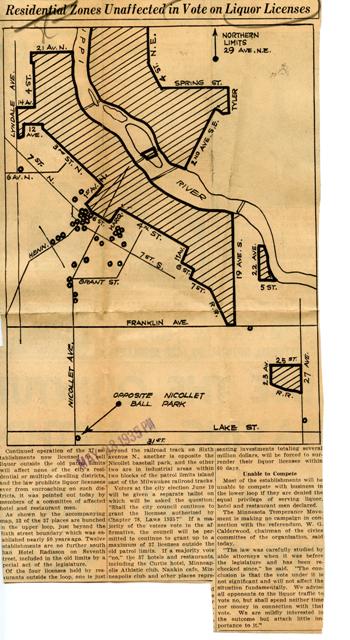
It’s map Monday. Ever wonder why it’s so hard to get a mixed drink south of Lake Street in Minneapolis? We can thank the historic “patrol limits,” which were incorporated into the city charter in the 1880s. The ordinance required bars and liquor stores to be concentrated in select parts of town, with the rationale that police could more easily control liquor-fueled crime if all of these types of businesses were in one place. The city’s largest liquor zone was the Gateway district on the banks of the Mississippi River. Another was the “Hub of Hell”–shown on this map at the intersection of 27th Avenue and 25th Street.
This map delineates the liquor patrol districts in 1935, about 18 months after Prohibition was rescinded. It also shows the 37 establishments allowed to serve liquor outside of the districts. This group includes legendary institutions like the Nankin Cafe and the Curtis Hotel; it also includes highly selective locales like the Minneapolis Club and the Minneapolis Athletic Club, which were renowned for barring anyone who did not belong to the city’s Yankee elite. City voters were being asked to determine whether these outliers could continue to serve liquor. Voters must have approved this request, as a defeat would have provoked a revolt of the well-heeled. The first families of Minneapolis would not have ventured into the increasingly seedy Gateway for their daily cocktail. The liquor patrol limits were rescinded in 1974, though it is still difficult in Minneapolis to get a liquor license or serve liquor outside of these historic limits. Clipping is from the Minneapolis collection, Hennepin County Central Library.