cropped version, Halloween_party_at_the_Hopewell_Hospital_Minneapolis_Minnesota, from MDL and Henn Co Medical collection

Halloween at Hopewell Hospital

Published October 31, 2014 by Kirsten Delegard

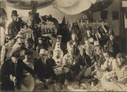
Happy Halloween. This haunting photo captures an unconventional commemoration of this day almost 100 years ago. Patients at Hopewell Hospital in North Minneapolis donned masks and witches’ hats, readying themselves for what appears to have been a somber party. Their day would not have been enlivened by any visitors. For these unsmiling jesters and grim-looking Indian chiefs, Halloween in 1917 was just another day in quarantine.

At the beginning of the twentieth century, Hopewell Hospital was the Minneapolis tuberculosis sanatorium. Situated in an isolated industrial quarter of the Camden neighborhood, the hospital looked out over city workhouse, the garbage “crematorium” and the brick works on the Mississippi River.

smaller version of 1914 plat map, hopewell hospital, plate 67, from hclib

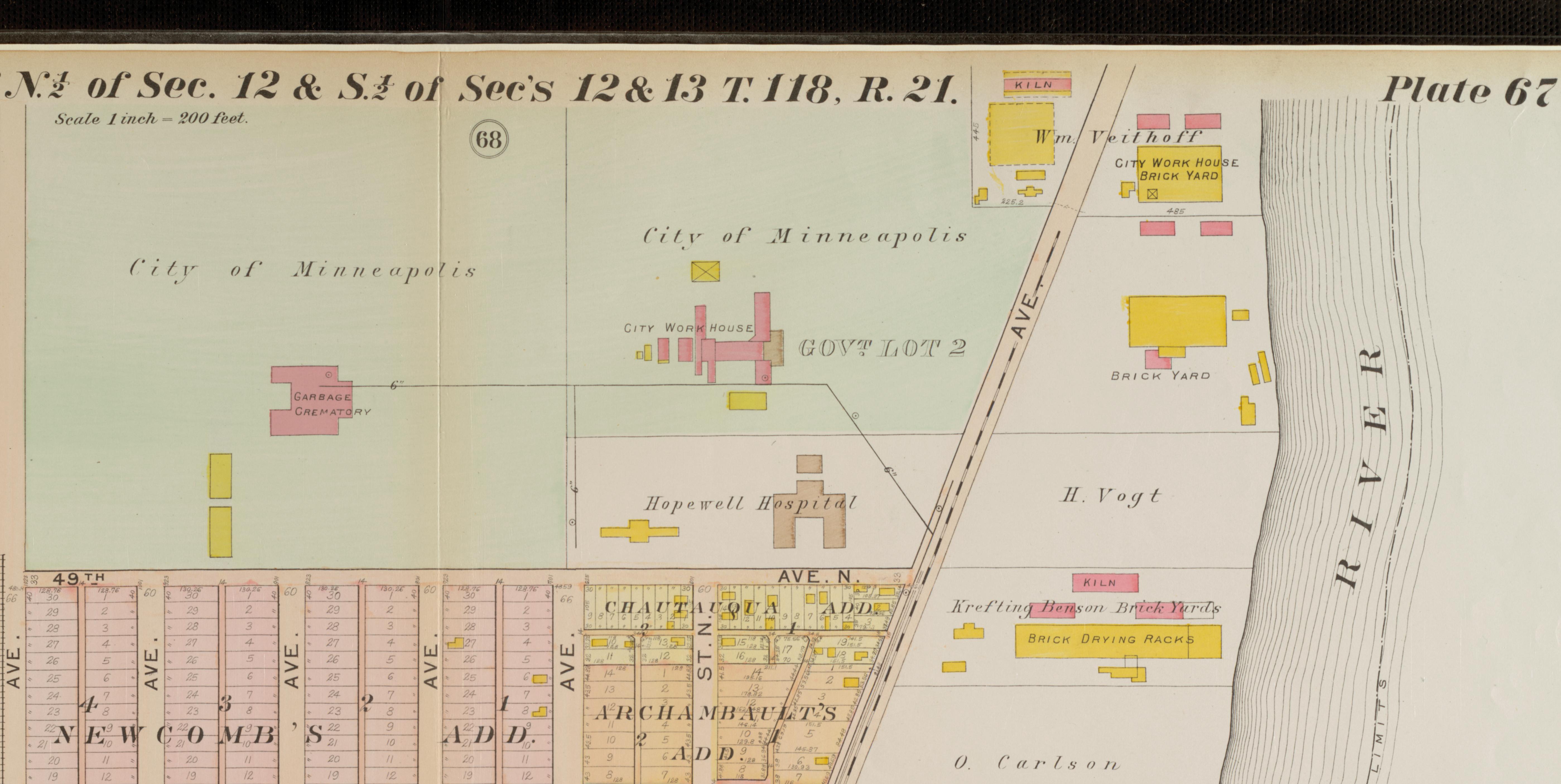
The Minneapolis plat map from 1914 shows Hopewell Hospital and its environs in the Camden neighborhood of North Minneapolis. The TB facility overlooked the “Garbarge Crematorium,” City Workhouse and brick yards. Map comes from the Special Collections of the Hennepin County Libraries.

Established in 1907, the facility housed the city’s tuberculosis sufferers, who were seen as an acute threat to the community. A bacterial infection that attacks the lungs and is easily transmitted through air droplets, tuberculosis was a common and deadly killer in these days before life-saving antibiotics. It spread easily in the overcrowded quarters of American urban neighborhoods. Tens of thousands of Minnesotans died from TB in the thirty years before these clowns and witches posed for the camera.

Thanks to the recent outbreak of Ebola, Americans are grappling anew with the question of quarantine. Though less common today thanks to widespread vaccinations and highly effective antibiotic treatments, the practice of quarantine was routine when this image was created. In the United States, local governments had imposed quarantines since the eighteenth century. Starting in the late nineteenth century, federal authorities had played an ever-larger role in this process, focusing their efforts on quarantining individuals with tuberculosis, cholera, diptheria, plague and yellow fever. Hopewell housed only TB patients. Minneapolitans with smallpox were brought to another facility located in present-day St. Louis Park, where the survival rate was very low.

Hopewell treated TB patients until 1924, when Hennepin County decided to bring all sufferers of this disease under the same roof at Glen Lake Sanatorium in modern-day Eden Prairie. Hopewell Hospital became Parkview Sanatorium and continued service as a public charity hospital until the building was eventually razed.

A Halloween photo from the closed ward of a TB sanatorium may be the stuff of nightmares for some viewers. Or inspiration for a new gothic novel by Ransom Riggs set in the post-industrial landscape of the Minneapolis north side.

But this image ultimately strikes me as more poignant than terrifying. We have no way to know the real identities of the woman posing as a gypsy fortune teller or the man attired like Uncle Sam. The fates of these patients–and the question of whether they survived their encounters with this deadly bacteria–will remain a mystery.

The day after Halloween–known in Mexico as the Day of the Dead–might provide an opportunity to remember this group of Minneapolitans. On Saturday morning we could amble through North Mississippi Regional Park in search of traces of Hopewell hospital, thinking about family and friends no longer with us. And take a moment to reflect on the myriad connections between the living and dead in our city.

The photo is from the Hennepin County Medical Center Museum Collection via the Minnesota Digital Library. The detail from the 1914 plat map of Minneapolis is from the Minneapolis Collection at Hennepin County Libraries Special Collections. Special thanks to librarian Ted Hathaway for providing Historyapolis with a high-resolution version of this image.

Social Welfare Map from the SWHA, Linnea Anderson

Mapping Charity in the 1920s

Published September 8, 2014 by Kirsten Delegard

After a summer hiatus, Historyapolis is returning to regular programming. Since it’s map Monday, today we’re featuring a map of “Charities and Social Welfare” in Minneapolis from the Social Welfare History Archives at the University of Minnesota.

This diagram maps the provision of private aid to Minneapolitans in the second half of the 1920s, showing the location of 62 private aid organizations.  The exact date of this map is unknown, but we know it was created after 1924, when the Phyllis Wheatley House was established and before 1929, when the YWCA moved to a new building on Nicollet Mall. In addition to the Wheatley House and the YWCA, the map includes the Maternity Hospital established by Martha Ripley and the Bethany Home for “fallen women” conceived by Charlotte Van Cleve, Harriet Walker, Euphoria Outlook and Abby Mendenhall.  It shows the city’s settlement houses and its public homes for the impoverished elderly. It indicates the locations of orphanages; non-profit employment agencies; homeless shelters and missions; and even the Legal Aid Society, which gave free legal advice to workers embroiled in wage disputes.

In the decade before the Great Depression, the city had little in the way of “public” or government-funded charity or welfare programs. Instead, city residents were served by the network of private charitable associations shown here. Between the 1880s and the 1920s–as the population of the city expanded exponentially–concerned Minneapolitans created these myriad organizations to address the hardships created by urbanization, immigration and industrialization. The needs were overwhelming. The city lacked decent affordable housing and had little in the way of sanitation services; children wandered the streets; working people struggled to maintain their health and their employment. These groups–which varied in focus, purpose and philosophy–struggled to make the urban environment more liveable and humane, paying particular attention to the welfare of vulnerable women and children.

The organizations shown here were likely linked by a common association with the Community Fund of the Council of Social Agencies, which ran a fund-raising campaign for associated social welfare groups in the city. This map was likely created by this group as a resource for both donors and social workers.

Created at the behest of the business community, the Council was animated by the principle of “scientific charity.” Business leaders were instrumental in championing this philosophy, which called on social welfare agencies to work together to prevent duplication of efforts and connect deserving individuals to the services they needed most. This coordination had a darker side as well. Proponents of scientific charity were focused on ensuring that recipients did not lose their will to work and did not game the system, drawing aid from multiple sources.

The landscape of private charity was transformed by the onset of the Great Depression, which threw one-third of the city out of work. This crisis overwhelmed private charity, which could not meet the overwhelming needs of the city during that decade. This economic collapse prompted the creation of a series of government welfare programs, which now work hand-in-hand with many of these same groups to address–but never satisfy–the social needs of the community.

Image credit: Linnea Anderson, Social Welfare History Archives, University of Minnesota Libraries.

social composition of near northside neighborhoods, map from a study of social conditions, 1925

“The mixture of races in this district is detrimental”

Published March 24, 2014 by Kirsten Delegard

It’s map Monday. This “Social Composition of North Side Neighborhoods” was drawn by a researcher associated with the Women’s Cooperative Alliance, which assembled an encyclopedic analysis of moral conditions in the city in 1925. The Cooperative Alliance was a consortium of women’s groups organized in April, 1917 to identify and eradicate conditions contributing to juvenile delinquency.  The Alliance had broad community support and attracted active representatives from nineteen local women’s organizations, including the Council of Jewish Women, the Woman’s Club of Minneapolis and the League of Catholic Women.

None of this would be obvious from this map, which seems merely to codify popular ethnic and class prejudices. The key on the right side shows how the research cartographer divided this district into sections defined by race, ethnicity, class and moral rectitude. It delineates blocks of “American Born, socially inadequate” from “American Born, socially adequate.” It distinguishes areas inhabited by “Colored” from those dominated by “Foreign Born Slavics” from those defined as “Jewish” and “Jewish, prosperous families.” These categories were separate from the sections annotated as “Miscellaneous Nationalities unskilled wage earning families” and “Scandinavian- thrifty comfortable homes.”

These crude characterizations obscure the complex and contradictory mission of the Women’s Cooperative Alliance, which employed twenty-four staff members, who had assembled this data in this report to demonstrate the need for a more wholesome urban environment for children. They lobbied for improved lighting in the city parks and better enforcement of juvenile curfew laws. They monitored the treatment of women and children in the judicial system—an issue that I will discuss more in a later post. They fought to mute the siren song of commercial amusements. The women associated with the Alliance would have been delighted to see the city shutter all of its dance halls, pool halls, movie theaters, candy stores and carnivals, just as Prohibition had closed its saloons.

The work of the organization had yet another element. More than 3,000 women volunteered with the Alliance to serve as block, precinct and ward workers, who were charged with visiting every home in their district to ascertain conditions and educate mothers. They hoped to reach out to immigrant mothers in particular, who they feared had neither the resources nor the knowledge necessary to keep their children out of pool halls, movie theaters, saloons and dance halls.

This map—which was part of the group’s five-part Study of Social Conditions–sought to guide this work by illuminating where education was most necessary. The accompanying text explained that the moral crisis was acute on the city’s North Side where the greatest “evils” were “prostitution and the liquor traffic. Not only are many of the furnished rooms over stores on Sixth Avenue vice resorts, but in many of the homes through the district women are prostituting themselves before their little children.” There was plenty of blame to go around, the writer asserted. “This vice is not confined to one race but occurs between colored and white, both Gentile and Jew. It does not include many Jewish women. The making of liquor, however, is reported by social workers to be common among the Jewish women and under cover of junk peddling it is easily distributed.” The problems of the North Side, according to the researcher, were rooted in its polyglot character. “The mixture of races in this district is detrimental,” she concluded. “The situation grows more serious because of the continual influx of migrant people of both races.”

The map is from a Study of Social Conditions, held at the Minneapolis Collection at the Hennepin County Central Library. Information about the Cooperative Women’s Alliance is from the vertical files at the Minneapolis Collection  and Leigh Ann Wheeler, Against Obscenity: Reform and the Politics of Womanhood in America, 1873-1935 (Baltimore: Johns Hopkins University Press, 2004).