Map Monday
Minneapolis: 1858
Published March 21, 2016 KEVIN EHRMAN-SOLBERG It’s map Monday. Today, we are going back to the 1850s when Minneapolis was little more than a muddy village. Although the city saw a surge of development during the second half of the decade, it was still a far away from the industrial metropolis it would become. The population…
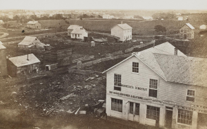
Read More“Minneapolis is Ruined”: The Tunnel Disaster of 1869
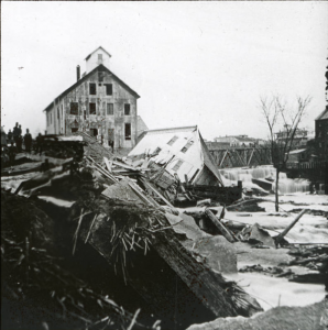
Published February 22, 2016 KEVIN EHRMAN-SOLBERG It’s map Monday. Our last post here at Historyapolis dug into the buried history of the Minneapolis riverfront, and explored the intricate tunnel system that powered the city’s milling district. These subterranean canals were the lifeblood of 19th century industry. Launch Application x Today, we are going back underground to examine another lost piece of industrial…
Read MoreThe Minneapolis Riverfront: An Underground History
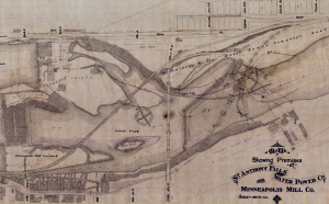
Published February 1, 2016 KEVIN EHRMAN-SOLBERG It’s map Monday. Today, we have an interactive mapping application built by former Historyapolis intern–and current graduate assistant at the Borchert Map Library–Kevin Ehrman-Solberg. This web map digs deep into the buried history of the Minneapolis riverfront. While residents readily embrace the “Mill City” moniker, that celebration is usually limited…
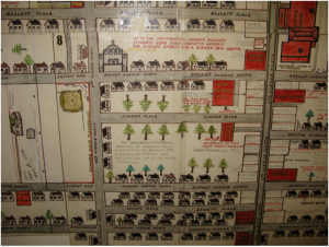
Read MoreMap Monday: Clarence Miller’s Lament for a Lost Intersection
Published May 11, 2015 by Kirsten Delegard It’s map Monday. Today we’re revisiting one of my favorite sources for Minneapolis history. Sometime in the 1950s, this “memory map” was created by Clarence Miller to document an area of the near north side that had been recently flattened by urban renewal. The original map–which hangs on…
Read MoreDancing and Revolution
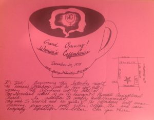
Published March 2, 2015 by Kirsten Delegard It’s map Monday. And it’s also women’s history month. This 1975 flier features a hand-drawn map directing readers to the “Grand Opening” of the “Women’s Coffeehouse” in the basement of Plymouth Congregational Church. Until it closed its doors in September of 1989, the Coffeehouse was the “most celebrated…
Read More“The Gateway” Revisited
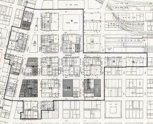
Published February 9, 2015 by Kirsten Delegard It’s map Monday. Today we have a diagram that shows the Gateway redevelopment project, a massive urban renewal effort that bulldozed a large chunk of downtown Minneapolis in the mid-twentieth century. This project opened a new era for Minneapolis and the nation. The largest urban renewal attempted in…
Read MoreMap Monday: Farewell to the Patrol Limits?
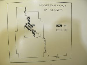
Published November 3, 2014 by Kirsten Delegard It’s Map Monday. Our diagram today shows the boundaries of the “liquor patrol limits” or the area where liquor sales were legal in Minneapolis for most of the twentieth century. This restriction–which was first incorporated into the city charter in 1884–has played a central role in the city’s…
Read MoreMap Monday: “To Elevate the Moral Standard of the Drama”
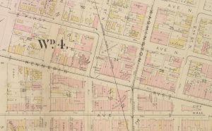
Published October 20, 2014 by Kirsten Delegard It’s Map Monday. Our selection today takes us back to 1885. This detail from the Hopkins plat map shows the intersection of Washington and Hennepin Avenues at the moment when this junction was the commercial heart of Minneapolis. On the right side of the image is the City…
Read MoreIndigenous Peoples Day: Celebrating American Indians in Minneapolis

Published October 13, 2014 by Kirsten Delegard It’s Map Monday. And it’s Indigenous Peoples Day in Minneapolis, which has adopted this new celebration to replace the long-controversial commemoration of Columbus Day. With one of the largest urban communities of Native Americans in North America, Minneapolis has been a long-time center for indigenous activism. And it…
Read MoreSmashing the stills: the rise and fall of beer brewing in Minneapolis

Published October 8 by Heidi Heller Today’s blogger is Heidi Heller, a senior history major at Augsburg College and an intern with the Historyapolis Project. As part of our continuing homage to Oktoberfest, today we continue the saga of beer brewing we began on Monday. For a map and early history click here. Brewing in…
Read MoreThe Geography (and history) of Beer
Published October 6, 2014 by Heidi Heller Today’s blogger is Heidi Heller, a senior history major at Augsburg College and an intern with the Historyapolis Project. It’s map Monday. Today we celebrate Oktoberfest by exploring the long history of beer brewing in Minneapolis. This map shows the known locations of 27 of the 30 different breweries that operated…
Read More“Blight by the Block”: Downtown is Dead
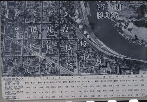
Published September 29, 2014 by Kirsten Delegard It’s map Monday. Last week–while working in the collections at the Hennepin History Museum– the Historyapolis team found hundreds of slides from the Minneapolis Housing and Redevelopment Agency (the precursor to our contemporary Community Planning and Economic Development agency ) that illustrated “redevelopment” of Minneapolis engineered by city…
Read MoreMapping The Replacements
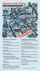
Published September 15, 2014 by Kirsten Delegard It’s map Monday. After a 23 year hiatus, Minneapolis cult-favorite band the Replacements played to a fawning crowd in St. Paul on Saturday. What’s up with that? We all know that the band belongs on the Historyapolis side of the river. And this cool map by Pat Ganley…
Read MoreMapping Charity in the 1920s

Published September 8, 2014 by Kirsten Delegard After a summer hiatus, Historyapolis is returning to regular programming. Since it’s map Monday, today we’re featuring a map of “Charities and Social Welfare” in Minneapolis from the Social Welfare History Archives at the University of Minnesota. This diagram maps the provision of private aid to Minneapolitans in…
Read MoreMapping Purple Rain
Published July 28, 2014 by Kirsten Delegard It’s map Monday. And it’s the 30th anniversary of the release of Prince’s movie and album, “Purple Rain,” which put the Minneapolis Sound on the international map. This website plots the locations featured in the song and movie, which makes it seem as though the international music icon spent…
Read MoreAquatennial Festival, 1940

Published July 21, 2014 by Kirsten Delegard It’s map Monday. And here we have a cartographic guide to the second Aquatennial festival, which was held July 20-28, 1940. The Aquatennial was conceived as part of the long-running effort by political and business leaders to remake the image of the city, which had been battered by…
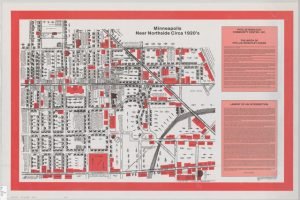
Read MoreSumner Field: A Tale of Two Maps on the North Side of Minneapolis
Published July 14, 2014 by Daniel Bergin It’s Map Monday. Our guest blogger today is Daniel Bergin, Senior Producer at Twin Cities Public Television and the director/producer of “Cornerstones: A History of North Minneapolis.” First broadcast in 2011 on TPT’s Minnesota channel, this documentary about the history of the enclave known as the “Northside” was…
Read MoreMapping Brothels
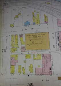
Published June 30, 2014 by Heidi Heller Today’s blogger is Heidi Heller. She is a senior history major at Augsburg College and an intern with the Historyapolis Project. It’s map Monday and we have another great image from the 1912 Sanborn maps in the Tower Archives at City Hall. These maps—which were created by the…
Read More