plan for civic center, 1934, city archives

Visions of Grandeur: A Civic Center for Minneapolis

Published May 21, 2014 by Stewart van Cleve

Today’s blogger is Stewart Van Cleve, a graduate student in the program for Library and Information Science at St. Catherine University. The author of Land of 10,000 Loves: A History of Queer Minnesota, Stewart discovered the tower archives at Minneapolis City Hall when he was researching the history of gay sexuality in the city. He has joined forces with Historyapolis to illuminate the holdings of this forgotten cultural repository.

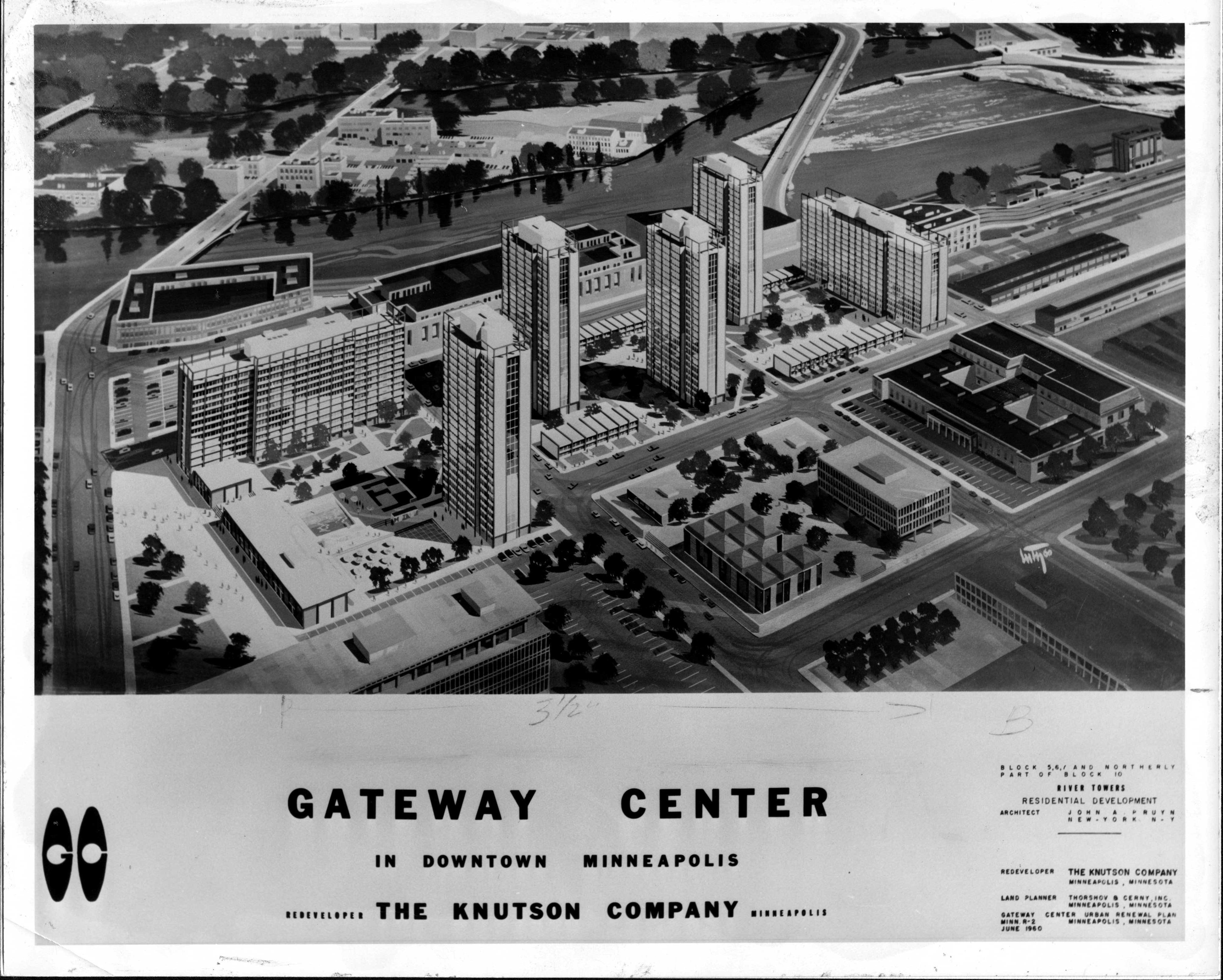
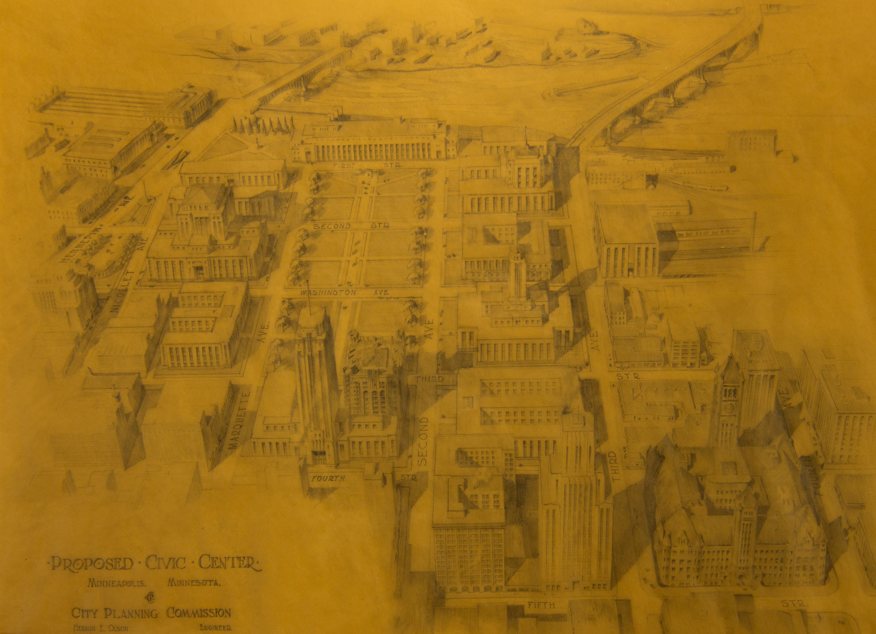
Thirty years before bulldozers descended on the Gateway– flattening forty percent of the city’s downtown–Minneapolis planners imagined transforming this problematic sector of the city. At the depths of the Great Depression–when the Federal Government was funding construction projects meant to restore public faith in capitalism and government–Minneapolis envisioned using some of this money to build a grandiose new “Civic Center” overlooking the Mississippi River.

Other than the main Post Office–which was constructed in 1934 and still dominates the downtown riverfront–little of this vision was realized. Drafted by the Minneapolis Planning Commission, this large plan illustrates the Main Post Office’s role in a broader scheme to replace the region’s largest skid row with a modernistic district of government buildings.

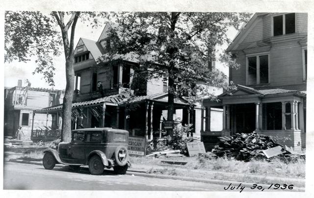
The “Civic Center” plan would have leveled hundreds of buildings, including the Milwaukee Road Depot. This version would have spared the beloved Metropolitan Building, which did not survive the later redevelopment of the area in the 1950s.  This renewal effort did spare the Milwaukee Road Depot, which stands today as one of the only remnants of this forgotten district.

The Post Office was to be situated on one end of a large park. Only part of this plaza was ever built and Pioneer Square never became the kind of public space planners envisioned. But the construction of this civic mall allowed the city to demolish what was widely considered a vice-ridden “slum.” The plaza was expected to serve as a parade ground for the National Guard, which had manned the barricades when labor unrest had turned the downtown into a battleground in 1934.

During its brief existence, Pioneer Square featured “The Pioneers,” a sculpture that now sits at Marshall Avenue and Main Street in Northeast Minneapolis. The park disappeared in a later round of redevelopment. The Churchill apartment tower was constructed on the site of the park in 1981.

This long-standing desire for a downtown plaza may be realized this year. On the other side of downtown, the new Vikings’ Stadium will be fronted by an enormous new park reminiscent of Pioneers Square. No one suggests that it may double as a military drilling ground.

At the same time, the main post office has become a topic of conversation among some planners and developers, who eye its walled-off design as outdated and in need of complete renewal. If the building falls to wrecking crews—an unlikely scenario, thanks to its location within the St. Anthony Falls Historic District—it would also fall victim to the very mentality that inspired it: a belief that urban rebirth occurs on the heels of total destruction.

The Civic Center Plan is from the tower archives at Minneapolis City Hall. Thanks for citizen researchers Eric Christenson, Dan Wilhelmsen and Chad Davis for digitizing this and so many other images.

new gateway center, publicity image, side 1 Oak Lake Park, July 30, 1936, smaller version

The twilight moments of Oak Lake Park

Published April 16, 2014 by Kirsten Delegard

Team Historyapolis spent yesterday in the tower archives at City Hall, unearthing more treasures that we’ll share in the weeks to come. Citizen-researcher Rita Yeada was occupied with the task of digitizing a  battered scrapbook of photos we found on our last visit. This fragile volume contains black and white snapshots from all the redevelopment projects undertaken in the 1930s, when the city began its three-decade crusade against urban “blight.” The collected images show the twilight moments of Oak Lake and other neighborhoods on the Near North Side, the first target of the city’s modernization campaign.

Oak Lake was a enclave on the edge of downtown memorialized by the renowned international correspondent Harrison Salisbury, who came of age amidst the faded grandeur of its Victorian mansions and curving streets. This neighborhood was flattened in 1936-1937 to make way for our municipal farmer’s market. A huge expanse of concrete–shadowed by the 1-94 overpass– now buries the neighborhood lake and any other evidence of this ambitious late-nineteenth century development.

When it was first developed in the 1870s, Oak Lake was home to the affluent, who built the city’s first neighborhood association and its second park. By the time that Salisbury was a  boy–around World War I–most of the neighborhood’s more prosperous denizens had decamped to Loring Park or Lowry Hill to escape the noise of the railroads and the stench of Bassett’s Creek. In his memoir, A Journey for Our Times, he remembers that “my mother thought our neighborhood was becoming a slum but I don’t believe she ever convinced my father of this. He saw Oak Lake as he had seen it with his father, planting the arborvitae tree and the red cedars on the lawn, putting in the thorn apple hedge.”

By the 1920s, Oak Lake had become home to new immigrants–mostly Jewish–from Eastern Europe. “To my playmates and their families, Oak Lake was a land beyond dreams,” Salisbury remembered. “They had seen nothing like the Victorian houses, the lawns, the curving streets, the sidewalks and the elms in Bialystok or Pinsk. In the villages, they had lived in izbas of mud and reeds, with thatched roofs and clay floors. Now they occupied three thousand square feet in a mansion, bigger than the landlord’s house. If your house backed up on the railroad yards, was anything more exciting?”

Both the exclusive Victorian ambience of Oak Lake in the 1870s and its dilapidated glory of the 1920s seem impossible to imagine today. Any remnant of these earlier periods have been obliterated from the modern streetscape. The gentle curves of Royalston and Lakeside Avenues have been replaced by a landscape of modern alienation. Parking lots, highways, expressways and industrial zones hide evidence of earlier eras.

The redevelopment of Oak Lake fundamentally changed Minneapolis, though not in the way that planners envisioned in the 1930s. When Salisbury was a boy, Oak Lake physically connected North Minneapolis to the city’s growing downtown. From his home on Royalston Avenue, Salisbury easily roamed to theaters on Hennepin Avenue and stores on North Lyndale. The construction of the market complex made these perambulations more difficult. The concrete expanse of the farmer’s market became a barrier between North Minneapolis and the rest of the city. This obstacle became only larger in the following decades, which brought the construction of Olson Highway and then the interstate.

This photo is from the scrapbook of 1930s redevelopment photos, Minneapolis City Archives. My great thanks to Rita Yeada, for digitizing these photos. And to archives-keeper Bob McCune, who welcomed us into the tower and helped us to discover its treasures.